Teledyne Optech Introduces UAV-Lidar Solution
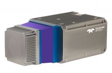
The Optech CL-90 is the first in a new family of compact Lidar (CL) products designed specifically for the unmanned aerial vehicle (UAV or ‘drone’) market drawing on Teledyne Optech’s...
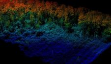
The Optech CL-90 is the first in a new family of compact Lidar (CL) products designed specifically for the unmanned aerial vehicle (UAV or ‘drone’) market drawing on Teledyne Optech’s...
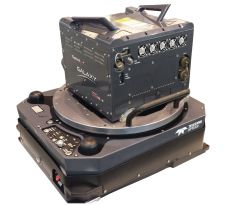
Teledyne Optech has announced the latest addition to its innovative line of airborne laser terrain mappers, the ALTM Galaxy PRIME which builds on the PulseTRAK and SwathTRAK productivity features of...

Teledyne Optech is launching survey instruments and workflow solutions for the productive and accurate collection of 3D spatial data at Intergeo 2016 in Hamburg, Germany. These include new solutions for...

Teledyne Technologies, through its Teledyne DALSA subsidiary, now fully owns Optech after acquiring the remaining shares. The company will be adopting the name Teledyne Optech, joining the Optech and Teledyne...
Teledyne DALSA, a subsidiary of Teledyne Technologies Incorporated, has acquired a majority interest in the parent company of Optech. Teledyne Technologies is a leading provider of sophisticated instrumentation, digital imaging...

Sven Cowan is NV5 Geospatial’s Programme Manager for Canada. He has over 20 years of experience in customer-facing positions within the geospatial information industry and has worked for multiple geospatial...
Teledyne Optech is launching a new customer service centre dedicated to the service of equipment for its European clients. Teledyne Optech is a Teledyne Technologies company and a leader in...
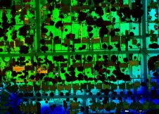
Teledyne Optech, the Canada-based advanced Lidar sensors company, has extended its Galaxy line-up to include the CM2000, a new sensor specifically designed for corridor mapping. With a true measuring rate...
Teledyne Optech has announced that its newest compact Lidar sensor, Teledyne Optech’s CL-360, is available for purchase through its second integration partnership with LiDARUSA. Optimized for UAV and mobile applications...

The AlphaUni 20 (AU20) Lidar system represents a new era in cost-effective, multi-platform mobile mapping solutions, according to CHC Navigation (CHCNav), a global leader in precision mapping, positioning and navigation...
This site uses cookies. By continuing to use this website, you agree to our Cookies Policy. Agree