3D Documentation of the Forth Bridge
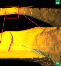
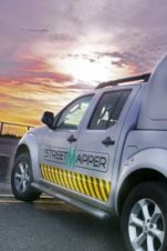
The iconic railway bridge and its companion road bridge have been scanned as part of a project to help inspire the next generation of Scottish engineers. Using a mobile mapping...
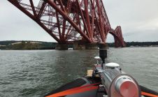
The iconic railway bridge and its companion road bridge have been scanned as part of a project to help inspire the next generation of Scottish engineers. Using a mobile mapping...

AGI marked its 25th anniversary with the annual conference in Chesford Grange Hotel near Kenilworth which attracted over 300 delegates for two days of intensive conference sessions and mild celebrations!...
The 70th anniversary of the Normandy Landings has just passed. To mark the occasion, GW looks back into archives of Geomatics World and its predecessor tile Surveying World, to discover...
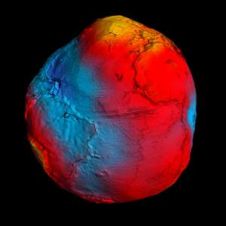
For decades, scientists have disagreed about whether the sea is higher or lower heading north along the east coast of North America. Gravity data from ESA’s GOCE satellite contributed to...

On 1 February 2013, it was exactly 60 years ago that floodwater burst dykes in the south-west of The Netherlands. Aerial photographs of the greatest flood disaster in the country's...
I feel we need to discuss a principle that seems to have taken hold in recent years: that everything on the internet is for free. Consumers – professional or otherwise...

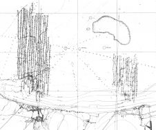
The goal of modern geodesy is to monitor changes in a range of physical processes in the solid Earth, the atmosphere, and the oceans in order to address the demands...
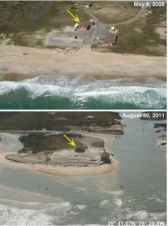
A series of before and after aerial photos of the Outer Banks show the impact of Hurricane Irene on the US coastline, highlighting several breaches that severed a state highway...
The Maptek I-Site 8800 laser scanner was used to develop a detailed model to assess the geotechnical features of one of Australia's most famous stretches of coastline. The scanner was...
Everyone who truly matters in the geomatics and surveying-related business will be travelling to Germany – or more precisely to the Bavarian city of Nuremberg – in the last week...
This site uses cookies. By continuing to use this website, you agree to our Cookies Policy. Agree