How Orthophoto UAS Compete with Traditional Surveying
One of the elements that makes Intergeo particularly dynamic is the so-called Trend and Media Forum. The Forum, based on the exhibition floor, functions as a platform for companies, giving...

One of the elements that makes Intergeo particularly dynamic is the so-called Trend and Media Forum. The Forum, based on the exhibition floor, functions as a platform for companies, giving...

Intergeo 2012 has come to an end. This year’s edition took place in Hanover, Germany and attracted 16,000 trade show visitors. 520 companies exhibited, bringing their latest innovations and trends...
Positioning and navigation company Trimble has been on a shopping spree, buying several companies – including remote sensing solutions business Gatewing – in what appears to be part of a...
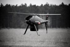
Schiebel and RIEGL, Austria, have successfully integrated the CAMCOPTER S-100 unmanned air system with the VQ-820-GU hydrographic airborne sensor. The integration marked the first time that the new airborne sensor...

Unmanned Innovation, a provider of development platforms for unmanned aircraft systems (UAS), announced that it has partnered with VectorNav Technologies to integrate VectorNav's VN-100 inertial measurement unit into its os-Series...
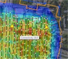
PIEneering, Finland, has released a complete photogrammetric software system, RapidStation suite, for processing digital imagery acquired with Unmanned Aerial Systems (UAS), aircrafts and helicopters. The software suite covers the entire...
UAS mapping is widely accepted as a new method for acquiring spatial image data. The main business opportunities clearly lie in projects which are too small to be of interest...

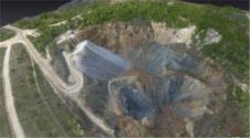
Edáfica, a Chilean environmental consulting company which owns an sUAS Stardust II, was hired by Collahuasi mining company to conduct a survey of biophysics and ecotypes. The aim of the...
This site uses cookies. By continuing to use this website, you agree to our Cookies Policy. Agree