Aibotix Presents Aibot X6 V2 Hexacopter
Aibotix from Kassel, Germany, has presented its new version of the Aibot X6. Aibotix has so far sold more than 150 UASs worldwide and is now entering the next stage...
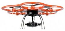
Aibotix from Kassel, Germany, has presented its new version of the Aibot X6. Aibotix has so far sold more than 150 UASs worldwide and is now entering the next stage...

Geo-matching.com, the product comparison website for devices used in geomatics, hydrography and related industries, has announced the addition of a new category for Unmanned Aerial Systems. The types of Unmanned...
Richard Groom reports back from the Survey Association’s recent UAV conference at the Newark showground in June. Sadly the weather limited the flying display but delegates still got a real...
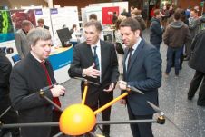
On Tuesday, 25 June 2013, the inauguration of the European Aerial Systems Training Academy (EUTA) took place in the Dutch municipality of Gilze en Rijen. It is offering a new...
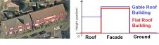
Multiple view oblique imagery of very high resolution is a rich source of semantic information about buildings and other objects on the Earth’s surface. The efficient extraction of semantic information...

The annual International LiDAR Mapping Forum (ILMF), held from 17-19 February in Denver, USA, attracted Lidar professionals from 30 countries who attended to learn about the latest advances in technology...
Some 230 experts from throughout Germany and across Europe came together at Jade Hochschule in Oldenburg, Germany, on 12 and 13 February for the Oldenburger 3D-Tage. Over 50 presentations along...
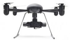
Draganfly Innovations, Canada, has partnered with Pix4D, Switzerland, to combine the value of a Draganflyer sUAS (small Unmanned Aerial System) with the Pix4D software package. This results in a system...
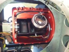
Simplex Mapping Solutions has introduced its new CaMundo camera system, an innovative miniature collection system that implements an advanced technology concept. The system weights 6kg and is able to collect...

The International Society for Photogrammetry and Remote Sensing (ISPRS) is one of the leading organisations within the geomatics sector and has a long-standing partnership with GIM International. We spoke to...
This site uses cookies. By continuing to use this website, you agree to our Cookies Policy. Agree