Evaluating Oil Spills Using Radar Satellite Imagery
ScanEx Center (Russia) has received and processed Radarsat-1 satellite imagery of the wreck site in the Kerch Strait where on 11th November stormy wind (up to 32 m/sec) and sea...
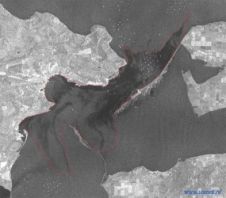
ScanEx Center (Russia) has received and processed Radarsat-1 satellite imagery of the wreck site in the Kerch Strait where on 11th November stormy wind (up to 32 m/sec) and sea...
Rotterdam is Europe’s largest logistical and industrial hub and its port is the gateway to a European market of 450 million consumers. It is accessed by five competing modes: road,...
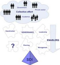
Spatial Data Infrastructure (SDI) is a framework of policies, standards and technology that enables data providers to publish, and users to access and integrate, distributed heterogeneous geospatial information. Despite recognition...
Established in 1868 by Govert van Oord, Van Oord is today a conglomerate of Dutch dredging companies, lately best known as constructor of Palm Island, Dubai, the ‘Eighth Wonder of...

Dimensions 2009, the fifth in this conference series, took place from 23rd to 25th February at the Mirage Hotel in Las Vegas. Attendees had the opportunity to network with industry...
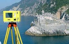
When surveying the coastline, the integration of bathymetric (below sea level) and laser scanning (above sea level) data causes problems due to the different imaging properties. However, by ensuring that...

View Larger Map The first priority after a major accident is of course taking care of passengers and crew of the crashed vehicle, train, vessel or aircraft. But shortly after...

Piracy at sea evolved along with the maritime trade. But in the recent years acts of piracy became much more frequent bringing criminal groups the income comparable to budgets of...
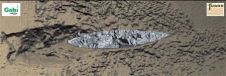
In December 2007, the Fugro survey vessel Geo Prospector was performing part of the Detailed Marine Survey for routing the proposed Galsi gas pipeline across the Southern Mediterranean Sea between...
PCI Geomatics is exhibiting at booth #2018 at the ESRI International User Conference in San Diego (CA, USA), this week. Conference attendees can view demonstrations on satellite image processing and...
This site uses cookies. By continuing to use this website, you agree to our Cookies Policy. Agree