Hyperspectral Imaging in South Africa
Hyperspectral Imagaing is one of the services provided by Southern Mapping, South Africa. The high-tech hyperspectral camera used by the company captures over 360 simultaneous images at up to 1...
Hyperspectral Imagaing is one of the services provided by Southern Mapping, South Africa. The high-tech hyperspectral camera used by the company captures over 360 simultaneous images at up to 1...
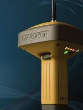
The new GR-5 GNSS receiver from Topcon Positioning Systems (TPS, USA) introduces its Fence Antenna technology and expanded channel support, providing high tracking sensitivity and multipath rejection in a compact...
Several Arab countries in North Africa and the Middle East are facing a wave of popular protest. Squares normally jammed with cars are now turned into campsites and crowded...

A ferocious tsunami triggered by an earthquake of magnitude 9.0 slammed into Japan’s eastern coast on Friday 11th March 2011. The wave reached heights of up to 23.5 metres and...

Recent Landsat satellite data captured by the USGS and NASA on 10th May shows the major flooding of the Mississippi River around Memphis, USA, and along the state borders of...
Spectral Imaging has delivered a compact, high-performance Long-Wave Infrared LWIR Hyperspectral Imager to a defence customer in a strategic geographical location. The complete delivery encompasses an AisaOWL thermal infrared hyperspectral...

Southern Mapping Geospatial (SMG), the black-owned South African arm of Southern Mapping Company celebrates its first anniversary this month. Highlights include the first full-visible near-infra-red (VNIR) and short-wave infra-red (SWIR)...
New technology is changing the face of mapping organisations around the world. Are national mapping agencies and traditional mapmakers able to keep up? The question is posed at the Spatial...
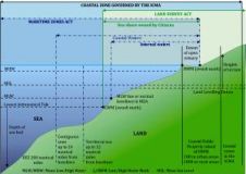
Since time immemorial the seashore has played an evolving but important role in society. In South Africa, the interface between rights in the land and the seashore has been the...
At 2:46 pm on 11th March 2011, a huge earthquake with a magnitude of 9.0 occurred, with its epicenter 130km offshore Ojika Peninsula, Miyagi Prefecture, North East Japan. It...
This site uses cookies. By continuing to use this website, you agree to our Cookies Policy. Agree