2007 Location Intelligence Conference
The 2007 Location Intelligence Conference, the premiere industry event focused on the use of location technology, has announced the agenda for this year’s conference. The conference will feature more than...
The 2007 Location Intelligence Conference, the premiere industry event focused on the use of location technology, has announced the agenda for this year’s conference. The conference will feature more than...
LuraTech (CA, USA) has introduced the LuraWave JP2 Image Content Server (ICS), Version 1.04. ICS is a software tool kit that allows organisations to develop advanced customisable, browser-based viewing applications...
Trimble (CA, USA)) has announced the keynote speakers for its International User Conference, Trimble Dimensions 2007. The conference, which will be held 5-7 November at the Mirage Hotel in Las...
Under the terms of a three-year agreement with ANTRIX Corporation Ltd. and EOTec, ASRC Management Services (MS) will have the exclusive distribution rights in the US to distribute satellite imagery...
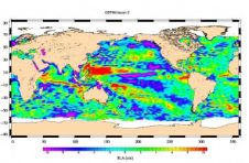
Less than a month after launch, the NASA-French space agency Ocean Surface Topography Mission (OSTM)/Jason 2 oceanography satellite has produced its first complete maps of global ocean surface topography, surface...
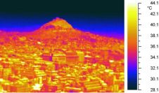
In a series of coordinated activities, called Thermopolis 2009, a group of thermal remote-sensing and urban-climate experts from Greece and Spain carried out ground-based measurements at various sites in and...

Océ has introduced CrystalPoint technology. This new technology combines the best of both toner and inkjet printing. The Océ CrystalPoint process converts color Océ TonerPearlsTM toner into a gel. This...
Trimble has acquired the assets of privately-held Callidus Precision Systems. Callidus is a provider of 3D laser scanning solutions for the industrial market. Financial terms were not disclosed. Callidus' products...
NEST (Next ESA SAR Toolbox) is an ESA toolbox with an integrated viewer for reading, post-processing and analysing ESA and 3rd party SAR data starting from Level 1. Distributed as...

From last June, the ScanEx Research and Development Center takes part in the international project Global Land Survey 2010. The GLS Program is aimed at building global satellite Earth coverage...
This site uses cookies. By continuing to use this website, you agree to our Cookies Policy. Agree