Airborne Lidar

3D TARGET was founded as a trading company and official distributor of non-destructive measuring instruments. In 2016, we created an internal R&D division dedicated to system integration and designed a...
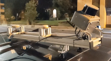
Klau Geomatics has introduced the Brumby RTK Lidar system, an innovative mobile mapping solution equipped with powerful Edge Compute capabilities, enabling the generation of highly precise georeferenced point clouds in...

Amuse oneself Inc., established in 2011, develops hardware and software for 3D measurements required for ICRT technology (Information, Communication and Robot Technology). Since our successful commercialization of the world’s first...

3D visualization is at the heart of many geospatial data applications. Progress in 3D visualization has drastically reduced barriers to entry for new products based on large datasets, thanks to...
RIEGL has announced the launch of two innovative topobathymetric scanners. These advancements mark a shift towards enhanced efficiency and precision in data collection across land and water interfaces. The RIEGL...

At the experimental forest site Paracou in French Guiana, a range of data is being collected to enable the short-term dynamics within the tropical rainforest canopy to be better understood...
The first commercial airborne Lidar systems appeared on the market in the mid-1990s. This active remote-sensing technology rapidly evolved to become the laser scanners which can today emit 400,000 pulses...
Although operational for more than twenty years, Airborne Lidar Bathymetry (ALB) has rarely been used in riverine areas. The US Bureau of Reclamation adopted it to study how flow change...
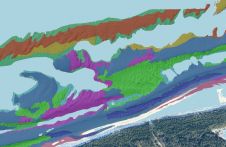
This article presents a novel methodological approach to understand and assess the suitability of airborne Lidar bathymetry for the automatic classification and mapping of the seabed. This solution allows recording of...
This site uses cookies. By continuing to use this website, you agree to our Cookies Policy. Agree