Isabelle Heitz
Isabelle Heitz is a geologist and geophysicist from University of Paris-Sud (DEA, 1984). She has worked in the field on dam studies in Algeria and the USA. She subsequently worked...

Isabelle Heitz is a geologist and geophysicist from University of Paris-Sud (DEA, 1984). She has worked in the field on dam studies in Algeria and the USA. She subsequently worked...
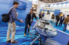
London’s docklands became home to a fleet of both manned and unmanned surface and subsea vehicles during this year’s Oceanology International 2018 (Oi18), reflecting an increasing focus on connected autonomous...

Historic England (HE) has announced the third edition of the technical guidance document, 3D Laser Scanning for Heritage, is now available for download from the HE website at https://historicengland.org.uk/images-books/publications/3d-laser-scanning-heritage/. This...

Over the last five years we have seen a clear move by technology manufacturers away from a ‘horizontal’ approach providing sensors and data capture systems for as many different customers...

Dominique Jagu was a dental surgeon in Maintenon, Eure-et-Loir, France, for 40 years. He officially entered the field of archaeology in 1994 (DEA prehistory at the Sorbonne) and is now...

An increasing number of professionals are discovering that Lidar is the most suitable solution for their needs. Lidar is a sophisticated method of mapping terrain features and man-made structures to...
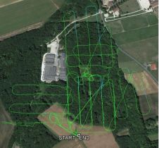
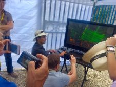
Due to the dense tree cover, Lidar was used in a drone survey of the Caesar’s Camp site, an ‘oppidum’ (fortified habitat) in France dating from around 100 BC. Archaeology...

An impressive line-up of speakers climbed the stage of the Royal Geographical Society in London, UK, on Thursday 26 October for the AGI Annual Conference, GeoCom17. Professionals in the geospatial...
'GIM International' took the opportunity to ask Tristan Allouis, chief technical officer and one of the co-founders of YellowScan, a few questions on the French company’s area of specialisation: Lidar mapping...
NUBIGON is a start-up company with offices in Turkey and Austria that has developed powerful reality capture software. The company’s solution visualises Lidar and photogrammetric point clouds in real time...
This site uses cookies. By continuing to use this website, you agree to our Cookies Policy. Agree