Batuhan Osmanoglu
Batuhan Osmanoglu is a research physical scientist at NASA-GSFC and holds a PhD in synthetic aperture radar (SAR) interferometry. He has been a part of Istanbul Technical University, University of...
Batuhan Osmanoglu is a research physical scientist at NASA-GSFC and holds a PhD in synthetic aperture radar (SAR) interferometry. He has been a part of Istanbul Technical University, University of...
As the FIG commission chairs near the halfway point in their terms, they reflect on the global and technological drivers influencing their work. This article describes the breadth of work...

NavVis, an innovator in indoor mobile mapping, has introduced the Cloud Processing Add-on for NavVis IndoorViewer, a cloud-based tool designed to enable users to quickly and easily convert laser scans...

Stephen Quick is an adjunct in the School of Architecture teaching the first-semester design studio in the Masters of Urban Design program. He returned to teach in the Urban Design...
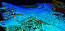
VeriDaaS is planning a high-density Lidar elevation data collection at a minimum of 30 points per metre (ppm) over the entire state of California in spring 2021 as part of...

This webinar gives you insights into our recently introduced UltraCam Osprey 4.1, its system architecture, key features, data processing and visualization. Alexander Wiechert, CEO of Vexcel Imaging, and Bernhard Schachinger,...
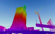
When it comes to 3D modelling for construction, what are the advantages and disadvantages of photogrammetry versus Lidar in terms of accuracy, complexity and cost? Breaking away from laser measurement...

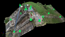
Working with Pittsburgh’s City Planning Department, a Carnegie Mellon University research team completed an in-depth study of the current use of 3D software for planning tasks and public communication.[1] The team...

In this interview, Thomas Harring emphasizes that the geospatial industry should use the momentum of the ‘new normal’ to further accelerate the sector’s ongoing transformation towards more customer-centric and autonomous...

The Spanish high-resolution land imaging mission, known as SEOSAT-Ingenio, will soon be shipped from Airbus in Madrid to Europe’s Spaceport in French Guiana, where it will be prepared for launch...
This site uses cookies. By continuing to use this website, you agree to our Cookies Policy. Agree