Intergeo 2008
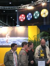
From 30th September to 2nd October, geodesy, geoinformation and land management took centre stage in Bremen, Germany. Intergeo 2008, organised by HINTE GmbH in association with the German Association of...
From 30th September to 2nd October, geodesy, geoinformation and land management took centre stage in Bremen, Germany. Intergeo 2008, organised by HINTE GmbH in association with the German Association of...
The Sixth Annual International Conference and Exposition on Laser Scanning and Digital Aerial Photography, ‘Today and Tomorrow’, was held at the President Hotel in Moscow from 6th to 8th December....
The term ‘geomatics’ came into use in the Latvian technical education system during implementation of the international project Geomatic Education in Latvia (GEMLA). The author provides some background and discusses...
The Geo-Siberia 2007 conference and exhibition was held in Novosibirsk, Russian Federation from 25th to 27th April 2007. Organised by the Siberian State Academy of Geodesy (SSGA) in Novosibirsk, it...
Policymakers, potential private investors, and the public have received valuable new information to help identify fault lines and the potential location of undiscovered water, oil and gas, and non-fuel mineral...
With a history stretching back to 1831, the National Mapping Agency (NMA) of Belgium has always respected the scientific approach. In 2006 it underwent a complete restructuring of work processes...
During the past year the Faculty of Geodesy at the University of Zagreb has introduced fundamental reform of all its education programmes, undergraduate, graduate and postgraduate doctoral studies, and established...
Intergeo 2007, the congress trade fair for geodesy, geoinformation and land management, opened its doors for the 13th time today. For three days, 475 companies from 28 countries will be...

Professor Orhan Altan, recently appointed president of the ISPRS, the international NGO representing more than a hundred nations and regions across the globe, believes the organisation should prioritise environmental monitoring...
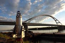
State-of-the-art geodetic and remote sensing techniques can prove their potential through particular engineering applications. Here we discuss load test measurements of bridges over the Danube. Prior to the particular bridge...
This site uses cookies. By continuing to use this website, you agree to our Cookies Policy. Agree