GNSS Rapidly Gains Ground
GNSS, short for Global Navigation Satellite System, is rapidly gaining ground as a tool in many different areas of work. Dutch contractor A.Hak is one of the companies at the...

GNSS, short for Global Navigation Satellite System, is rapidly gaining ground as a tool in many different areas of work. Dutch contractor A.Hak is one of the companies at the...

As Europe prepares for October 2011 launch of the first Galileo satellites, a worldwide ground network is being put in place. Contracts signed in June 2011 cover satellite control and...
The active ICA Commission on Mountain Cartography last reported its work in these pages in April 2005. Since then there have been regular business meetings and biannual workshops. The 6th...
"There are not many above-ground structures that aren’t captured, accounted for and on view to the public online. So why isn’t this true for what’s below the surface too?" ask...
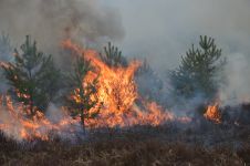
The number of wildfires has increased dramatically in recent years due to diminishing forest health caused by the drastically changing climate across the world. Longer dry-weather periods and pressure from a variety of pests and diseases, e.g. bark beetles, are affecting the large forest areas in Northern Europe. In addition to financial losses, these impacts are resulting in lower carbon accumulation and vast ecological changes. The number of wildfires has increased dramatically in recent years due to diminishing forest health caused by the drastically changing climate across the world. Longer dry-weather periods and pressure from...
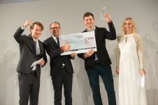
Tuesday 20 October 2015 was certainly a day to remember for the Munich-based start-up Building Radar, which provides a global, satellite-based online database for new construction projects. The company secured...
ESA has recently recovered imagery from the oldest synthetic aperture radar (SAR) in space, providing renewed views of a changing Earth. The retreat of two large glaciers in southeast Greenland...

Planet was founded with the mission to image the Earth every day and make change visible, accessible, and actionable. Over the past decade with our customers, Planet has revolutionized the...
Time series of satellite radar images are very useful for monitoring the extent and dynamics of floods and the devastations caused. A time series of four medium resolution radar images...
Synthetic Aperture Radar (SAR) is becoming more and more requested in the commercial and scientific world, especially considering the latest developments toward compact, high-resolution and cost-effective sensors. Since 2008, MetaSensing...
This site uses cookies. By continuing to use this website, you agree to our Cookies Policy. Agree