Imaging solutions combined with AI and 5G hold promise for forest health and wildfires
Reducing risks to firefighters, settlements and infrastructure
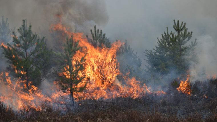
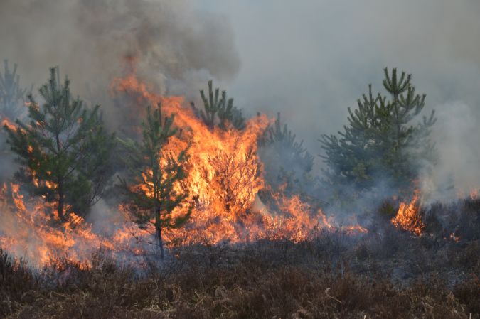
The number of wildfires has increased dramatically in recent years due to diminishing forest health caused by the drastically changing climate across the world. Longer dry-weather periods and pressure from a variety of pests and diseases, e.g. bark beetles, are affecting the large forest areas in Northern Europe. In addition to financial losses, these impacts are resulting in lower carbon accumulation and vast ecological changes.
In 2022, a total of 2,397 wildfires were registered in Germany alone. More than 3,058 hectares of forests were destroyed, predominantly in the federal states of Brandenburg and Saxony. Monitoring forest areas with aircraft or uncrewed aerial vehicles (UAVs or ‘drones’) can help to detect potential issues in time. In addition, observation towers equipped with the latest camera and sensor technology – and combined with artificial intelligence (AI) to detect smoke columns as an indication of a wildfire – can be a perfect solution to assist in the fight against the widespread destruction of wildlife habitats.
Forest monitoring project
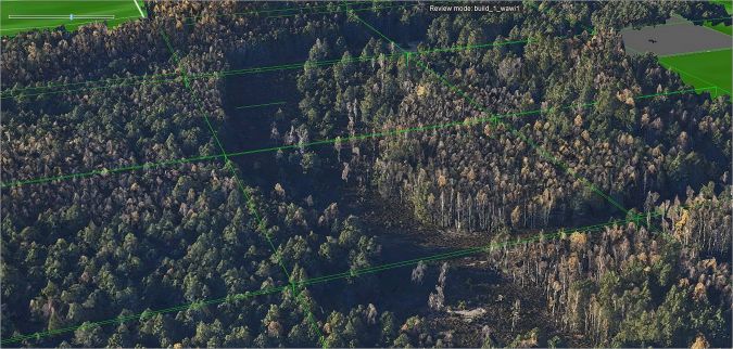
A research project – initiated by Landkreis Goerlitz in Saxony and Germany’s Federal Ministry for Digital and Transport (BMDV), in cooperation with the firm Geotechnology, Geoinformatics and Services GmbH (GGS) – focused on monitoring an overall forest area of 170km2 in the northeast of Germany. The project delivery was based on multiple approaches. Due to the large area covered, a surveying aircraft and UAVs were used for monitoring by air, while on the ground observation towers with the latest sensor technology and ground sensors were used.
Camera setup for aerial survey
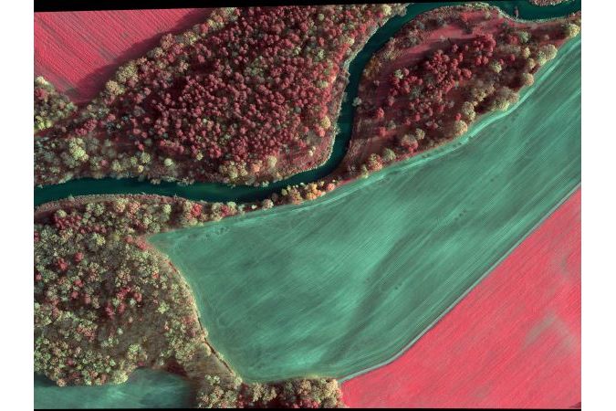
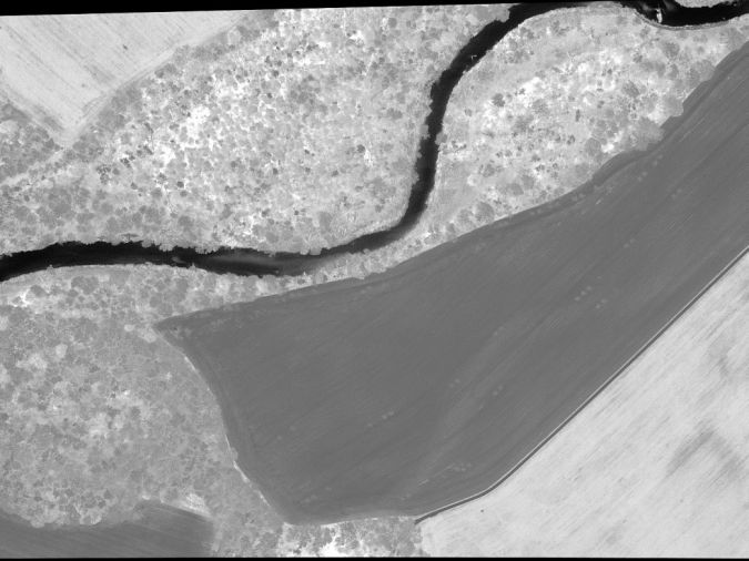
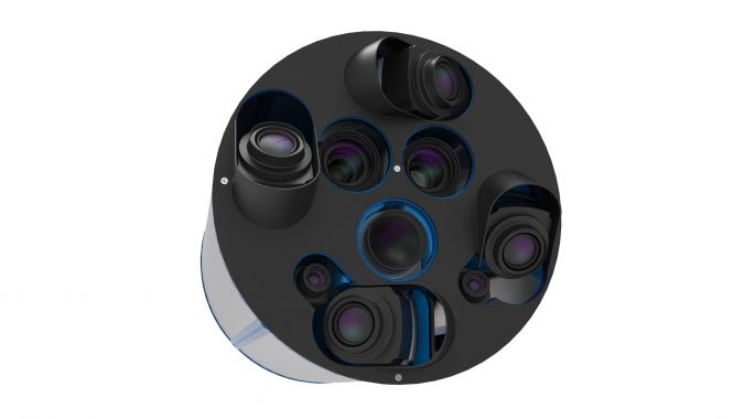
The camera setup for the aerial survey was based on GGS’s OIS technology with the addition of near-infrared (NIR) and thermal cameras. GGS chose a Phase One iXM-RS 150 with a 90mm lens for nadir imaging. Two additional Phase One Achromatic iXM-100 cameras with NIR filter (bands 700-850nm and 750-850nm) and two 70mm lenses were added. For generating a 3D surface model, four Phase One iXM-100 oblique cameras, each equipped with an 80mm lens, were also integrated into the camera pod. Alongside the nadir cameras, two further thermal cameras were used to capture the entire footprint at lower resolution to determine the influence of microclimate changes on forest health.
Data processing and model generation
The gathered RGB, CIR and NDVI data was first processed with Phase One’s iX Capture software, before being further processed with specialized photogrammetric software to generate true orthophotos. The red edge data was generated after producing the orthophotos of both NIR bands and refined by raster conversion between the two NIR orthophotos. The RGB data of the oblique system (nadir and oblique) was processed with Skyline’s software package Photomesh to generate a 3D model.
Applications in forest management
The resulting data models can be used for a variety of applications, including:
- Forest health assessment: The RGB,NIR, CIR, NDVI and red edge orthophotos can be used by forest experts to detect high-risk areas for wildfires, areas suffering from drought or pests/diseases – such as the bark beetle – or to assess soil health status. These areas are then labelled as high risk and hence have higher priority regarding fire observation. The red edge detection in the 700-750nm band allows for faster and easier detection of health problems than NIR/CIR images alone. Thus, it can be labelled as a rapid indicator of stress within trees.
- Emergency maps: The RGB orthophotos can be used as part of the emergency navigation system for firefighters in combination with other information, such as the accessibility of paths, lakes for accessing water, information about critical infrastructure, and inaccessible areas. This data, e.g. a true orthophoto mosaic, is part of a cloud-based GIS application. It is frequently updated with ancillary data, e.g. UAV-gathered data about the dimensions and dynamics of wildfires as well as the associated risks for nearby settlements and infrastructure. This navigation application can also be used to coordinate and direct emergency responders.
- 3D simulation: The 3D data from the oblique cameras can be used to generate a perfect 3D model of the area being processed with Skyline’s Photomesh. Using Skyline’s TerraExplorer software helps to perform analytics in the surface model, e.g. visual line of sight of the observation towers and optimized UAV flights to detect seats of . Using different AI modules, the 3D model also allows simulation of wildfires to check whether the fires are visible from remote points like the observation towers, or from UAV flights at different heights and using different flight strategies.
Next steps
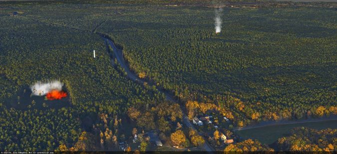
Currently, there are three observation towers available within the 170km2 of forest studied in this research project. However, only one of them is equipped with a camera system, and that camera system is based on older technology. As a next step, an innovative gimbal-mounted camera array capturing RGB, NIR, AC and thermal data will be installed on two of the three towers. The gimbal will scan the area at 270 degrees, while the cameras will capture images with a 60% side overlap. The resulting data will be streamed via 5G to a central crisis management server and analysed using AI algorithms to detect wildfires. If a wildfire is detected, an alarm will be triggers and a UAV will be deployed to assess the situation. In combination with the observations from the other towers, the location of the fire can be easily calculated and verified.
Smaller areas can be monitored with UAVs equipped with RGB, NIR and red edge cameras. To enable a longer flight time, these drones only carry small-format compact cameras. After the alarm is raised, a single UAV will be deployed initially. In certain situations, a UAV swarm may be sent out to observe a larger area to check for additional fires. The data gathered – in combination with visual inspection of wind speed and direction – is crucial to determine the speed and direction of the spread of the fire. Streamed via the 5G network, the combination of all gathered data informs the strategy and deployment of the emergency services, while mitigating the risks to firefighters, settlements and infrastructure.
For detailed insights, scan both QR codes.


Value staying current with geomatics?
Stay on the map with our expertly curated newsletters.
We provide educational insights, industry updates, and inspiring stories to help you learn, grow, and reach your full potential in your field. Don't miss out - subscribe today and ensure you're always informed, educated, and inspired.
Choose your newsletter(s)


