3D geospatial visualization
3D visualization is at the heart of many geospatial data applications. Progress in 3D visualization has drastically reduced barriers to entry for new products based on large datasets, thanks to...

3D visualization is at the heart of many geospatial data applications. Progress in 3D visualization has drastically reduced barriers to entry for new products based on large datasets, thanks to...

iXBlue is an independent worldwide established group serving both the civil and military sectors by designing and delivering first-rate differentiated technologies, products, systems and integrated solutions for the marine, maritime,...

Maxar Intelligence has been awarded a contract to supply the National Geospatial-Intelligence Agency (NGA) with a Precision3D Data Suite bundle. This comprehensive package covers an extensive area of 160,000 square...

Over the past 20 years, various initiatives have been launched reflecting the importance of cadastral data for land management and spatial development. But how have these initiatives enhanced the possibility...

Dublin City University (DCU) has partnered with Bentley Systems to spearhead the creation of an advanced digital twin of its campus as a pivotal element of its Smart DCU initiative....
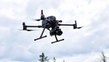
YellowScan, a familiar name in the mapping and land surveying realm, is making a noteworthy entrance in the hydrographic sector with the introduction of its pioneering UAV-based bathymetric Lidar solution....
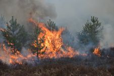
The number of wildfires has increased dramatically in recent years due to diminishing forest health caused by the drastically changing climate across the world. Longer dry-weather periods and pressure from a variety of pests and diseases, e.g. bark beetles, are affecting the large forest areas in Northern Europe. In addition to financial losses, these impacts are resulting in lower carbon accumulation and vast ecological changes. The number of wildfires has increased dramatically in recent years due to diminishing forest health caused by the drastically changing climate across the world. Longer dry-weather periods and pressure from...
Cyberhawk has entered into a global partner agreement with Phase One. Together, they will deliver the utmost standard of industrial inspections to the most discerning customers, leveraging the advanced capabilities...
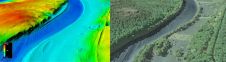
The US Geological Survey (USGS) and Dewberry have jointly released a new topobathymetric Lidar dataset for the Potomac River, extending from the Potomac Highlands in West Virginia to the Chesapeake...
iXBlue is organising its first user conference and training event, to be held at the Sheraton Suites in Houston, USA, from 25 to 27 February, with iXBlue product training offered...
This site uses cookies. By continuing to use this website, you agree to our Cookies Policy. Agree