Land Surveying
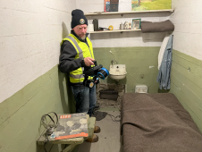
The rugged 22.5-acre site of the notorious US island prison Alcatraz has been digitally captured in a world-leading project involving multiple mapping technologies. With the team camped in the jail’s infamous cells for three weeks during the cold San Francisco winter, this historically, biologically and architecturally important location was recorded in unprecedented 3D detail. We discussed the project with project head Pete Kelsey and team member Dr Jeremy Sofonia. The rugged 22.5-acre site of the notorious US island prison Alcatraz has been digitally captured in a world-leading project involving multiple mapping technologies. With the team camped in the jail’s infamous cells...
A topographic survey collects information about the land's natural and man-made characteristics, as well as its terrain. Buildings, fences, trees, and waterways are permanent structures that accurately define the ground and its boundaries. The elevation of the terrain is depicted by land contours and spot levels. Architects, engineers, construction builders, and others utilize topographic maps to precisely visualize their sites and speed up development. A topographic survey collects information about the land's natural and man-made characteristics, as well as its terrain. Buildings, fences, trees, and waterways are permanent structures that accurately define the ground...

Incorporating smart methodologies in cadastral surveying is improving the land acquisition system in Ghana. Traditional cadastral surveying is time-consuming and, if not planned out well, could cost a fortune to...

3D TARGET was founded as a trading company and official distributor of non-destructive measuring instruments. In 2016, we created an internal R&D division dedicated to system integration and designed a...

Amuse oneself Inc., established in 2011, develops hardware and software for 3D measurements required for ICRT technology (Information, Communication and Robot Technology). Since our successful commercialization of the world’s first...
Klau Geomatics has introduced the Brumby RTK Lidar system, an innovative mobile mapping solution equipped with powerful Edge Compute capabilities, enabling the generation of highly precise georeferenced point clouds in...

Trimble has recently unveiled the Trimble MX90 mobile mapping system. Integrating advanced Trimble GNSS and inertial technology with Trimble field and office software, the MX90 offers a comprehensive field-to-finish mobile...
The Open Maps For Europe 2 (OME2) project has revealed plans to boost the utilization of European cadastral data. This includes efforts to enhance its discoverability and accessibility. As part...
This site uses cookies. By continuing to use this website, you agree to our Cookies Policy. Agree