A Spatial Turn in History
Geography and history are sister disciplines. In fact, geography as a field of scientific research evolved from the study of history. Whereas geographers have the perspective of space, historians consider...
Geography and history are sister disciplines. In fact, geography as a field of scientific research evolved from the study of history. Whereas geographers have the perspective of space, historians consider...
This article presents a first overview of the legal issues involved in geospatial data-gathering in space. Matters of security and privacy must be resolved within a legal framework if satellite...
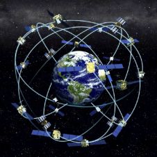
Receiver position is calculated from the position of satellites and the distances to them. Distance is calculated from the time a radio signal travels between satellite and receiver. But how...
The Respond project is intended to develop into a sustainable humanitarian aid service. By working in concert with other information providers, humanitarian organisations can quickly and easily access maps, satellite...
The area of agricultural fields within the European Union (EU) are checked against claims to ensure that farmers receive the right amount of subsidies. This measure, stemming from EU Common...
The Government of India on 19th May 2005 approved a radical New National Map Policy, ending decades of restrictive practise that had hampered geospatial development on the subcontinent (see Pinpoint...
The Government of India on 19th May 2005 approved a radical New National Map Policy, ending decades of restrictive practise that had hampered geospatial development on the subcontinent (see Pinpoint...
Writing a text or revising a spreadsheet and saving it...editing a map or digital photo and saving it…a seemingly unlimited amount of data, all stored inside the computer on the...
The X Conference of the Iberoamerican Society of Geographic Information Systems (XIBCGIS) will take place in the San Juan City (Puerto Rico) on 6 to 9 September 2005. The organisation...
As successor to the first GIS PLANET 98 conference, Planet 2005 took place in Estoril, the scenic beach resort on the Atlantic Ocean southwest of Lisbon, Portugal from 30th May...
This site uses cookies. By continuing to use this website, you agree to our Cookies Policy. Agree