Wageningen University Geo-Info Sciences and Remote Sensing

Thanks to frequent observations from the year-old Sentinel-1A radar satellite, scientists are improving the remote sensing technique to map ground deformation and hence opening new doors for earthquake and volcano...

The organisation committee of the 36th Asian Conference on Remote Sensing (ACRS) is inviting remote sensing professionals to join the conference. ACRS 2015 is being held from 19 to 23...
Lidar, short for Light Detection and Ranging surveying, represents a sophisticated measuring system leveraging the power of light. Widely recognized for its versatility, Lidar is extensively applied in diverse fields...

The organising committee of the 36th International Symposium on Remote Sensing of Environment, which will start on 11 May 2015, is inviting geomatics professionals to join this key event in...
World-renowned remote sensing experts gathered in Valencia, Spain, in early September to train the next generation of Earth observation scientists in the exploitation of satellite data for land applications. As...
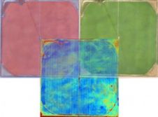
Tetracam and Pix4D have jointly announced a global alliance that combines the technological strengths of both companies to improve farming by means of airborne remote sensing. The alliance is only...

Airborne Technologies has announced that a further Tecnam MMA has started operation in Russia. The Tecnam MMA is a twin-engine aircraft for remote sensing missions developed by the Austrian company....
The organising committee of the 36th International Symposium on Remote Sensing of Environment (ISRSE) has issued a call for papers. The event will take place on 11-15 May 2015 in...
‘Operational RS Applications: Opportunities, Progress and Challenges’ is the main theme for the ISPRS TC-VIII mid-term symposium which will be held at Hyderabad, India, from 9-12 December 2014. The mid-term...
This site uses cookies. By continuing to use this website, you agree to our Cookies Policy. Agree