12th Brazilian Remote Sensing Symposium
The 12th Brazilian Remote Sensing Symposium (SBSR) was held in the Convention Center, Goiânia, Goiás State Capital from 17th to 21st April 2005. This was the biggest symposium since the...
The 12th Brazilian Remote Sensing Symposium (SBSR) was held in the Convention Center, Goiânia, Goiás State Capital from 17th to 21st April 2005. This was the biggest symposium since the...
Sanborn (CO, USA) has announced that the company has been selected to provide GIS topographic mapping services for Pima Association of Governments (PAG), a Arizona, USA-based coalition of local, state...
Global Marketing Insights (OH, USA) has launched a comprehensive research study of international remote sensing markets for aerial and satellite data. The study follows a contract with the US National...
The CBERS Programme, a co-operative Chinese-Brazilian Earth Resources Satellites Programme with versatile cameras, has realised a vast success of the Brazilian data distribution policy that is leveraging research and business...
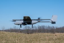
In a new strategic partnership, Inertial Labs' RESEPI Payload Lidar technology will be integrated into E38's advanced E455 drone platform. This collaboration marks a significant milestone in the utilization of...
Lidar, short for Light Detection and Ranging surveying, represents a sophisticated measuring system leveraging the power of light. Widely recognized for its versatility, Lidar is extensively applied in diverse fields...
GAF AG has won an international tendering process issued by the German Federal Agency for Cartography and Geodesy (BKG) for the provision of remote sensing data. The framework agreement includes...

Intermap has won a US$20 million contract to map the Indonesian island of Sulawesi this year. The contract is the first phase of the Indonesian national topographic basemap programme to...
In a project in Haiti, several remotely sensed indicators were assessed to predict the completeness of Open Street Map for use in disaster relief and to guide future mapping efforts....

ISPRS Technical Commission III on Remote Sensing (2016-2020) has this year once again been working to actively promote and support developments in the remote sensing field. With ten working groups...
This site uses cookies. By continuing to use this website, you agree to our Cookies Policy. Agree