GEO-SPATIAL SOLUTIONS Ltd

Planet was founded with the mission to image the Earth every day and make change visible, accessible, and actionable. Over the past decade with our customers, Planet has revolutionized the...
Exprodat has recently announced the design and release of a new course: Using GIS for Surface Analysis in E&P. The course looks at how raster and vector surface data management...

Dr Ferdinand Vettermann holds a PhD in Geoinformatics and is a cognitive solutions engineer at the German geointelligence company Deeeper.technology. As an expert in geoinformatics, he is responsible for linking...
ITT Corporation has announced aninitiative to support the integration of its software technology with the ArcGIS platform from Esri. ITT's Industry Solutions will use ENVI tools in ArcGIS to build...
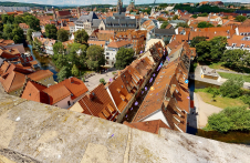
Lidar-powered Matterport technology was employed to create a 3D digital twin of the most famous inhabited bridge globally, the Krämerbrücke, situated in the city of Erfurt, Thuringia, Germany. The Krämerbrücke...
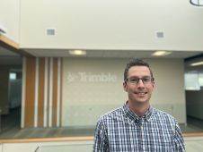
In this Q&A, we asked Trimble’s Jeff Turgeon to share his insights into the current state of the sector and his expectations for the future. Looking at terrestrial laser scanners,...
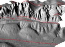
Innovative methodologies based on artificial intelligence (AI) are lowering the barriers and democratizing the use of 3D digital twins in the geospatial industry. Digital twins are revolutionizing the geospatial industry,...

The Open Geospatial Consortium (OGC) membership seeks to form a new Land Administration Domain Model (LADM) Standards Working Group (SWG). Public comment is sought on its draft Charter. Comments are...

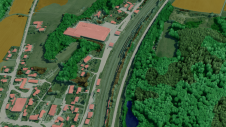
Looking at a satellite image one sees squares (i.e. pixels) representing landscape, although the actual shapes of roads, rivers, lakes, forest and nature reserve might more accurately be represented by...
This site uses cookies. By continuing to use this website, you agree to our Cookies Policy. Agree