AI-generated 3D digital surface models from digital orthophotos
Catalyst for large-scale digital twin applications
Innovative methodologies based on artificial intelligence (AI) are lowering the barriers and democratizing the use of 3D digital twins in the geospatial industry.
Digital twins are revolutionizing the geospatial industry, merging real-time data and advanced modelling to provide precise, real-world representations. These virtual environments enhance decision-making across sectors like urban planning, environmental management and infrastructure optimization. While costs have become more manageable, 3D digital twins – particularly those with height data – remain complex and expensive. Artificial intelligence (AI) now offers a solution. Innovative AI-driven methodologies for extracting elevation data from imagery are lowering barriers, expanding the applications of digital twins and democratizing their use.
The increasing importance of digital twins to support decision-making processes has long become a core driver in product development for the geospatial industry. Digital twins serve as dynamic replicas of physical landscapes, integrating real-time geospatial data with advanced modelling and simulation. They enable precise mapping, monitoring and analysis of complex terrains, urban environments and natural ecosystems. Across a wide range of industrial segments, from smart city planning to agriculture and land management, reality is mapped in the form of visible and explorable geospatial data and used for planning with far-reaching implications. Although advancements in technology, increased availability of data and growing adoption across various industries have contributed to falling acquisition costs for digital twins in recent years, they still remain complex and therefore expensive.
This is especially true for 3D digital twins containing height information. Since this information is not always available or is obtained from cost-intensive Lidar scans or photogrammetry, which is less accurate and requires multiple images, height information often still forms a bottleneck in digital twin development. One way to reduce manufacturing costs is to save on procurement costs by producing AI-generated data in-house. Although not directly intuitive, the generation of digital terrain models based on elevation data obtained from aerial imagery is very effective. To reduce costs and prices, the German geointelligence company Deeeper.technology has developed such a method which allows the extraction of digital surface information directly from aerial and satellite imagery. In effect, a neural network is trained to calculate height information for each pixel. In simple terms, this makes it possible to convert 2D image data into intelligent estimations of 3D terrain information.
Turning 2D image data into 3D terrain information
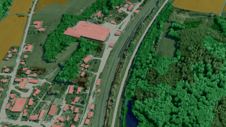
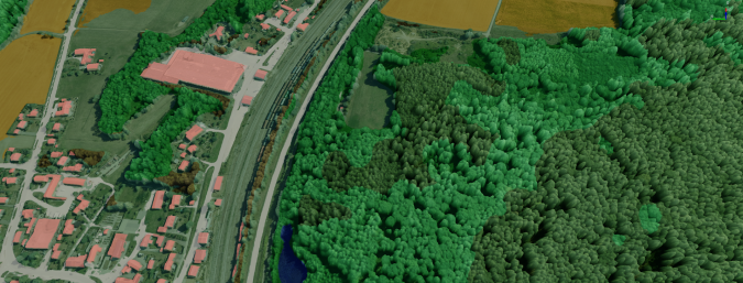
To get from 2D image raster information to the 3D terrain model, a method called monocular depth estimation is used. Traditionally, this involves training a neural network to estimate the distance relative to the camera of each pixel given a single (monocular) RGB image. Deeeper uses a variation of this method whereby the deep neural network determines the distance to the ground instead of the distance to the camera. The result in this case is not a depth map, but a direct regression of an elevation map, which contains the ground distance for each pixel – the digital surface model. By adding a low-resolution digital elevation model, a digital terrain model can thus be determined in a very short calculation time. Both models – the digital surface model and the terrain model – then form a cost-effective building block for a large variety of digital twins (see Figure 1 for an example).
AI-generated backbone for diverse applications
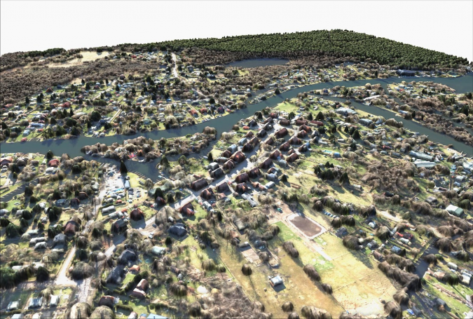
The information can be generated in-house and is inexpensive to produce. This makes digital twin technologies accessible to a larger portion of businesses and governmental institutions. The information obtained can be used as a backbone in a wide spectrum of digital twin applications. For example, Deeeper uses the generated data to create a three-dimensional digital twin of the land cover of the Earth’s surface (Figure 2) or solar cadastres in which height information and thus also shading are taken into account (Figure 3).
The cost-effective production of the various digital twin applications in turn has a major impact on the number of use cases that are made possible by these models. Among others, these include real estate and property evaluation, environmental impact assessment, flood and ecological disaster management, and strategic grid and infrastructure planning. Thus, the multiple application possibilities – together with the lower acquisition costs – not only increase the impact on measuring climate change and managing climate change activities, but also lower the threshold for the use of digital twins.
Benefits and limitations
Like any technological innovation, the automatic generation of digital terrain models does not exclusively offer advantages. The need for manual data generation or to purchase data from third parties gives way to reliance on other input data, such as aerial imagery in this case. Even though these are usually inexpensive, availability similar to Lidar is not universal. Moreover, AI generation of such complex models requires not only a lot of expert knowledge, but also the appropriate hardware with sufficient computing power. In addition, although the accuracy is sufficiently accurate compared to traditional methods, there will be some loss of quality and accuracy.
However, due to the large scales on which calculations can be performed, these are quickly compensated by the benefits. In addition to the abovementioned economic benefits, automation also offers the advantage that the resources gained through automated processes can be used elsewhere. Moreover, automated processes are less prone to human error and ensure that data is processed and analysed consistently over time.
Besides this, it can be assumed that, in the future, further building blocks of digital twins will be provided until it is possible to automatically generate complete digital twin models. Due to the fact that a digital twin typically involves a multidisciplinary approach – combining domain-specific knowledge, sensor data integration, modelling, simulation and data analysis – it can be considered a big step that sub-processes such as data collection and preprocessing can now be automated by the model developed by Deeeper. Nevertheless, it is essential to note that, even if certain aspects of digital twin development can be automated, human oversight and expertise are typically required to ensure that the digital twin accurately represents the physical system it models and provides actionable insights.
Conclusion
Digital twins have emerged as indispensable assets in the geospatial industry, empowering precise mapping, monitoring and decision-making across various sectors. While their potential is vast, the costs associated with developing 3D digital twins, particularly those incorporating elevation data, have historically posed challenges. However, pioneering use of AI to extract elevation data from digital orthophotos represents a significant step towards cost-effectiveness and accessibility. This innovation not only broadens the scope of digital twin applications, but also underscores the importance of human expertise in guiding their development. As digital twins continue to evolve, they hold the promise of revolutionizing geospatial insights and decision-making on a global scale.


Value staying current with geomatics?
Stay on the map with our expertly curated newsletters.
We provide educational insights, industry updates, and inspiring stories to help you learn, grow, and reach your full potential in your field. Don't miss out - subscribe today and ensure you're always informed, educated, and inspired.
Choose your newsletter(s)


