Andrews Surveying
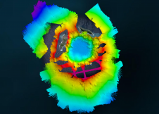
The Tonga Eruption Seabed Mapping Project (TESMaP) is a collaborative mission to discover the undersea impacts of the January 2022 eruption of the Hunga-Tonga Hunga-Ha’apai volcano. Using their collective knowledge,...
Surveyors and GIS professionals have the highest standards when it comes to their tools and trade. It is therefore no wonder that many surveyors are turning to drones for their mapping and...
ComNav Technology has introduced a new product called Venus Laser RTK, which allows positioning without the need for a range pole. For the prism-free total station, the principle behind this...
This site uses cookies. By continuing to use this website, you agree to our Cookies Policy. Agree