GEO Business 2024: unlocking geospatial innovation at ExCeL London
GEO Business, the UK’s premier geospatial event, is celebrating its tenth anniversary when it returns to ExCeL London on 5 and 6 June 2024. This edition promises to be the...

GEO Business, the UK’s premier geospatial event, is celebrating its tenth anniversary when it returns to ExCeL London on 5 and 6 June 2024. This edition promises to be the...

Diamond Aircraft has delivered the new DA62 MPP SurveyStar to RIEGL. Setting a new standard for high-capability, low-cost airborne survey missions, this robust and modern survey configuration variant of the...

The Earth observation industry seems to be on a slow burn – but why? Brace yourself for a ‘rollercoaster ride’ through Earth observation as this article unravels the mysteries behind...

SI Imaging Services (SIIS) is gearing up for the launch of an innovative 100%-commercial optical satellite with high-end resolution capabilities. This strategic initiative, in collaboration with its parent company Satrec...

The brand-new United Nations Global Geodetic Centre of Excellence (UN-GGCE) is now operational at the United Nations campus in Bonn, Germany. Nicholas Brown, head of office of the UN-GGCE, is...

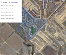
RSK Group has awarded a new enterprise GIS contract to Esri UK to boost the use of geospatial technology across its operations and support ambitious growth plans. This three-year agreement,...

In the ever-evolving landscape of climate change, geospatial science emerges as a key player in navigating the complexities of our transforming world. The European Association of Aerial Surveying Industries (EAASI)...

SingularXYZ has presented its latest innovation for geospatial professionals: the X1 Pro GNSS receiver. This new device aims to refine precision in surveying technology with a range of features tailored...
Trimble has unveiled the integration of the Trimble Applanix POSPac Cloud post-processed kinematic (PPK) GNSS positioning service, featuring CenterPoint RTX, with the UAV-based mapping and data collection capabilities of DroneDeploy’s reality...

SimActive has reported that the use of its Correlator3D product along with ground control points can enhance, extend and validate photogrammetry projects. GCPs are critical in photogrammetry projects, but there...
This site uses cookies. By continuing to use this website, you agree to our Cookies Policy. Agree