New Web Mapping Product
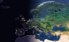
Cadcorp, UK, has unveiled during AGI GeoCommunity 2011 an addition to the Cadcorp Spatial Information System (SIS) product family: Web Map Layers. This is an off-the-shelf but extensible web mapping...
Cadcorp, UK, has unveiled during AGI GeoCommunity 2011 an addition to the Cadcorp Spatial Information System (SIS) product family: Web Map Layers. This is an off-the-shelf but extensible web mapping...
The latest version of the EDINA Digimap service has gone live. The service is a co-operation of Cadcorp and the EDINA National Data Centre. Launched in 2000, the EDINA Digimap...
ESRI announces that its Web mapping APIs are available at no cost to users who are building applications for use in internal and noncommercial environments. ArcGIS Web mapping APIs have...
EuroGeographics is drawing attention to the indispensable role of official national geospatial data in enhancing Copernicus Services, particularly within land monitoring and emergency management. This highlights a reinforced partnership between...

RIEGL has announced the launch of two innovative topobathymetric scanners. These advancements mark a shift towards enhanced efficiency and precision in data collection across land and water interfaces. The RIEGL...

GrabMaps is preparing to launch KartaCam 2, a crowdsourced mapping solution combining high-end imagery and AI capabilities to transform local expertise into effective navigation solutions. With the introduction of enhanced...

JOUAV has released the JoLiDAR-1000 Lidar sensor designed specifically for uncrewed aerial vehicles (UAVs or ‘drones’) as the latest addition to its array of high-performance Lidar sensors for use in...

Sven Cowan is NV5 Geospatial’s Programme Manager for Canada. He has over 20 years of experience in customer-facing positions within the geospatial information industry and has worked for multiple geospatial...
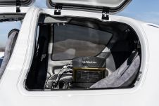
Diamond Aircraft and Vexcel Imaging have announced the next collaboration for a further expansion of Diamond’s special mission aircraft high-end sensor portfolio. The partnership will integrate the UltraCam Dragon 4.1...

Visitor registration is now open for GEO Business, the UK's largest geospatial event. The free-to-attend expo, tailored for geospatial professionals seeking to harness the potential of location intelligence, will return...
This site uses cookies. By continuing to use this website, you agree to our Cookies Policy. Agree