JOUAV unveils advanced airborne Lidar sensor
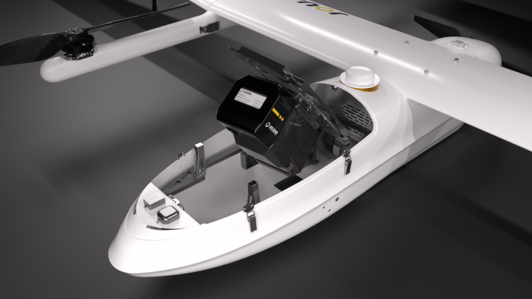
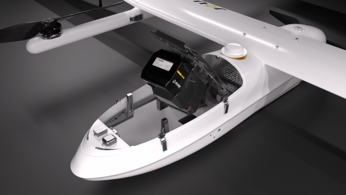
JOUAV has released the JoLiDAR-1000 Lidar sensor designed specifically for uncrewed aerial vehicles (UAVs or ‘drones’) as the latest addition to its array of high-performance Lidar sensors for use in UAV applications such as GIS, surveying and precision powerline inspections.
“The JoLiDAR-1000 medium-range Lidar sensor underscores our commitment to innovation and excellence in providing cutting-edge Lidar drone solutions that empower our customers to achieve their goals more efficiently and effectively,” states Eric Lee, product manager at JOUAV.
The JoLiDAR-1000 comes with a host of features tailored to numerous mapping and surveying applications. These include advanced technology utilizing a 1,000m medium-range laser scanner and full-frequency RTK+IMU fusion technology. The result is a measurement accuracy of 5mm and a repetition accuracy of 10mm. With a line scanning speed ranging from 10 to 300 lines/s and a maximum of 7 returns, the sensor ensures detailed and accurate data collection.
The JoLiDAR-1000 also excels in enhanced detection capabilities, featuring a FOV of 100° and an angular resolution of 0.001°. This enables high-precision detection of objects even at extended distances of up to 1,000m.
Wide array of applications
The sensor’s compact design ensures easy deployment and control without compromising on performance. Integrated with mature technologies such as GNSS high-precision positioning systems, inertial navigation systems, and a 26MP RGB camera, the JoLiDAR-1000 offers seamless and efficient data acquisition.
With streamlined operation processes that eliminate the need for base station setup and ground control points, coupled with high-precision POS solution computation and point cloud fusion capabilities, JoLiDAR-1000 emerges as a fitting choice for a diverse array of applications. These include terrain mapping, powerline inspection, mining surveying, coastline measurement, emergency mapping, natural resource surveying, and immersive 3D modelling, among others.
According to JOUAV, the unveiling of JoLiDAR-1000 marks a significant milestone in the realm of UAV Lidar technology, aimed at reshaping industries and elevating standards of efficiency and precision in data acquisition and analysis.
Headquartered in Chengdu, China, the company specializes in the research & development, production, sales and service of industrial drones. With the ambition to take a leading role, it actively promotes the application of vertical takeoff and landing (VTOL) fixed-wing UAVs, driving innovation in the industry.
For more details, see here.

Value staying current with geomatics?
Stay on the map with our expertly curated newsletters.
We provide educational insights, industry updates, and inspiring stories to help you learn, grow, and reach your full potential in your field. Don't miss out - subscribe today and ensure you're always informed, educated, and inspired.
Choose your newsletter(s)


