Mapping a Busy Road and Railway Intersection
As part of the UK’s A14 improvement scheme, Datumate was required to map a busy A14 highway junction including a highway intersection and a railway line. Traditional total station usage posed hars...

GIM International's "Case Studies" section delivers comprehensive examinations of actual geospatial projects. These studies shed light on the hands-on use of technologies and methodologies in the geospatial realm, empowering professionals to address obstacles efficiently and catalyze innovation. (Image courtesy: Christoph Holst/Technical University of Munich)
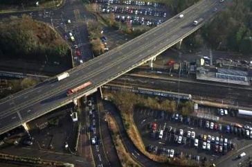
As part of the UK’s A14 improvement scheme, Datumate was required to map a busy A14 highway junction including a highway intersection and a railway line. Traditional total station usage posed hars...
This site uses cookies. By continuing to use this website, you agree to our Cookies Policy. Agree