Oleg Vassilev
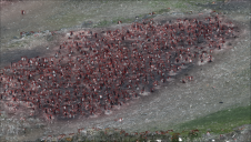
Oleg Vassilev has been contributing to the Bulgarian Antarctic campaigns since 2017. One of his focuses is drone-based photogrammetry data collection necessary for glaciological and biological observations to study the...

Oleg Vassilev has been contributing to the Bulgarian Antarctic campaigns since 2017. One of his focuses is drone-based photogrammetry data collection necessary for glaciological and biological observations to study the...
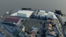
Remote sensing surveys in Antarctica based on unmanned aerial vehicles (UAVs or ‘drones’) have become a very important approach for a wide range of studies. Mapping free-from-ice-and-snow terrain and monitoring...
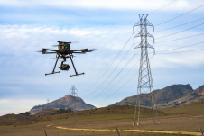
Inspired Flight Technologies and Phase One have jointly launched a new plug-and-play solution that combines aerial imaging and flexible operations to meet diverse surveying and inspection needs. Inspired Flight Technologies...
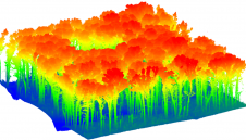
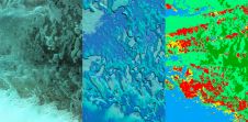
When considering Lidar technology for forest inventory, it is essential to evaluate the trade-offs of each platform. This article provides some pointers. There is a critical need for rapid, rigorous, reproducible...
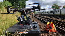
Plowman Craven has introduced Vogel Freedom, a UAV survey system designed for rail infrastructure surveying. Vogel Freedom is a survey-grade solution that surveys tracks without physical access. A novelty in...
What are the primary technical differences between crewed and uncrewed aerial vehicles and satellites when it comes to capturing images of Earth? Where do they overlap, and where do they...

We asked James Kavanagh, head of land & resources with The Royal Institution of Chartered Surveyors (RICS), about the challenges facing the geospatial industry, the technological developments that will drive...

Alexandros Skondras is a PhD candidate in the Spatial Planning and Development department of the Aristotle University of Thessaloniki, Greece. He holds a BSc in Architectural Engineering (2013) and an...
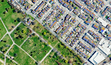
A team from Greece studied the use of aerial imagery to achieve wide coverage of a predefined geometrical area of interest in a project to explore the contribution of UAVs...
Russell Bollig and John Welter from Hexagon’s Geosystems division recently sat down with 'GIM International' to discuss the impact of AI on the geospatial industry. The conversation focused on hot...
This site uses cookies. By continuing to use this website, you agree to our Cookies Policy. Agree