Multi-sensor Coastal Mapping
Fugro has tested a multi-sensor approach to balance growing data needs with limited agency budgets. Coastal mapping programmes are quickly becoming a priority for government agencies across the globe. The desire...
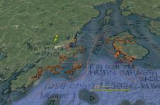
Fugro has tested a multi-sensor approach to balance growing data needs with limited agency budgets. Coastal mapping programmes are quickly becoming a priority for government agencies across the globe. The desire...
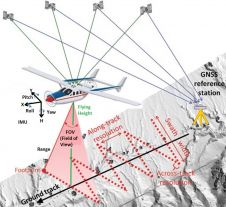
Today, automatic matching of overlapping aerial imagery and airborne Lidar are the main geodata technologies for capturing dense point clouds of the Earth’s surface. The sampled points are used for...
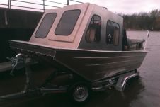
Surveying Britain’s 2000 miles of inland waterways is specialised work. Kate Rowlatt and John Williams show how a new compact custom system aboard a bespoke survey vessel is capturing cleaner...

Geodata collection in tropical regions is difficult because of cloud cover and dense forestation. However, radar signals are able to penetrate clouds, and the P-band can even pass through vegetation...
The role of SAR imagery in emergency rapid response to global disaster is firmly established. Properties of imagery that must be considered in acquiring TerraSAR-X data for flood monitoring and...
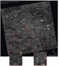
GAF AG (Germany) has entered into an assistance agreement with Earth Remote Sensing Data Analysis Centre (ERSDAC) for distributing PALSAR products effective from July 2007. ERS ERSDAC PALSAR L-band data...
Both overview and detail are necessary during all phases of disaster management: preparedness, prevention, emergency response, recovery, mitigation and damage assessment; and both can be simultaneously provided by earth observation...
The combination of 3D-laser scanning and side-scan sonar can be very beneficial for mapping complicated waterside areas; the two systems are complementary. High-resolution surveys were performed over a two-year period...
Vexcel Corporation (CO, USA) has announced CCDMap-a highly automated satellite image processing system for Coherent Change Detection (CCD) from commercial SAR data. CCDMap performs image formation, interferometric processing, ortho-rectification, and...
This site uses cookies. By continuing to use this website, you agree to our Cookies Policy. Agree