Jonathan Arthur Quaye-Ballard
Jonathan Arthur Quaye-Ballard is a professor and head of the Department of Geomatic Engineering at KNUST, where he has worked for the past 20 years. He also holds a BSc...

Jonathan Arthur Quaye-Ballard is a professor and head of the Department of Geomatic Engineering at KNUST, where he has worked for the past 20 years. He also holds a BSc...

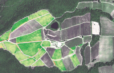
Incorporating smart methodologies in cadastral surveying is improving the land acquisition system in Ghana. Traditional cadastral surveying is time-consuming and, if not planned out well, could cost a fortune to...
Investigadores en Grecia revelan que el uso de imágenes por satélite puede mejorar la calidad del vino y ayuda a manejar la cosecha de uvas. En un reciente estudio de...
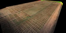
Terra Drone has announced an enhancement of its Lidar capability spanning the agricultural, construction and mining sectors. This follows the appointment of Lidar specialist Jeremy Sofonia, previously of Rhino Imaging,...
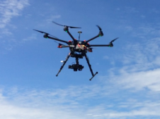
Terra Drone, one of Asia’s leading service providers of unmanned aerial vehicles (UAVs), and Hitachi Construction Machinery, a renowned manufacturer of construction and mining equipment, have announced a partnership to accelerate full-automatic...
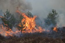
The number of wildfires has increased dramatically in recent years due to diminishing forest health caused by the drastically changing climate across the world. Longer dry-weather periods and pressure from a variety of pests and diseases, e.g. bark beetles, are affecting the large forest areas in Northern Europe. In addition to financial losses, these impacts are resulting in lower carbon accumulation and vast ecological changes. The number of wildfires has increased dramatically in recent years due to diminishing forest health caused by the drastically changing climate across the world. Longer dry-weather periods and pressure from...
Blaze Terra of Eternix, Israel, supports visualisation and processing of multi-band imagery. This new capability allows real-time presentation and manipulation of thousands of colour bands in high dynamic range (both...
Vexcel Imaging GmbH will roll out release 2.0 of its UltraMap photogrammetric software to customers beginning 25th January 2010. UltraMap 2.0 continues the tradition of providing a flexible and scalable...
This site uses cookies. By continuing to use this website, you agree to our Cookies Policy. Agree