The Expanding Use of UAVs in Construction
It is an exciting time for geospatial professionals. The data that can now be obtained using unmanned aerial vehicles (UAVs, or drones) opens up previously impossible opportunities in many different...
It is an exciting time for geospatial professionals. The data that can now be obtained using unmanned aerial vehicles (UAVs, or drones) opens up previously impossible opportunities in many different...
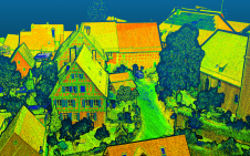
Lidar mapping based on unmanned aerial vehicles (UAVs or ‘drones’) can generally be thought of as a close-range version of manned airborne laser scanning. In brief, lower mobilization costs and...

Since the launch of the first Very High Resolution commercial satellite, European Space Imaging has been providing the best possible spatial resolution to the European market. From our inception in...
According to Global Market Insights, the worldwide Lidar in mapping market is expected to exceed US$4 billion by 2026. The rising demand to reduce the risks associated with natural disasters such...
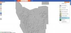
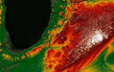
A beta version Digital Elevation Model (DEM) has been constructed for Tasmania (Australia) by MRT geoscientists Dr Claire Kain and Colin Mazengarb, including the most recent Lidar imagery captured during the...
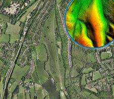
Staff from the Michigan Department of Environment, Great Lakes, and Energy (EGLE) in the USA are using Lidar technology to view the topography (elevation) of the state at a resolution...
A detailed laser mapped aerial survey from Bluesky is helping the City of London Corporation understand and plan for the future of London’s most extensive, natural grassland. The historic environment...

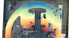
Earlier this year, SPH Engineering, the company behind the UgCS mission planner for UAV platforms, launched the new automatic Facade Scan tool of UgCS. The solution, especially developed for drone...

Combining big data with satellite imagery can help cities such as Kampala, the capital of Uganda, to better prepare for natural disasters such as urban flooding and make more informed...
Airbus has enlarged its high-resolution imagery portfolio following an agreement to leverage capacity from the S1-4 satellite built by Surrey Satellite Technology Limited (SSTL). This imagery from Vision-1 delivers full...
This site uses cookies. By continuing to use this website, you agree to our Cookies Policy. Agree