Lingli Zhu
Dr Lingli Zhu received her doctoral and master’s degrees in the field of Remote Sensing and Photogrammetry from Aalto University in 2015 and 2007, respectively. Currently, she is leading an...

Dr Lingli Zhu received her doctoral and master’s degrees in the field of Remote Sensing and Photogrammetry from Aalto University in 2015 and 2007, respectively. Currently, she is leading an...
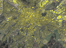
The National Land Survey of Finland (NLS) is a good example of how artificial intelligence (AI) is entering national mapping agencies. Approximately two years ago, NLS set up the Advanced...

Presagis recently released the V5D Plugin for Unreal Engine, which lets users load GIS-generated V5D digital twins into Unreal Engine. This integration enables the creation of highly realistic visualizations and...
NV5 Global has made a significant move to strengthen its geospatial capabilities by acquiring Axim Geospatial. Axim provides end-to-end geospatial services and solutions to clients across a range of sectors,...
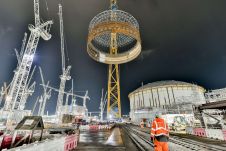
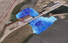
EDF, a French electric utility company, has partnered with Esri UK to implement an enterprise GIS for Hinkley Point C (HPC) nuclear power station, one of the largest and most...
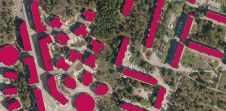
Global climate change and, in some areas, the lack of a cheap and reliable energy supply are contributing to the expansion of photovoltaics, both regionally and worldwide. In addition to...

Bluesky Geospatial has announced the launch of its MetroVista 3D aerial mapping programme in the USA. The service employs a hybrid imaging-Lidar airborne sensor to capture highly detailed 3D data,...

During the Open Data Challenge hackathon held in Tashkent, the capital of Uzbekistan, more than 200 students, divided into 50 teams, spent three days using geodata to tackle the country's...

Hexagon's Safety, Infrastructure & Geospatial division together with Ness Czech will provide the Czech Railway Administration with a Digital Technical Railway Map (DTRM). This railway-specific GIS solution will give the...
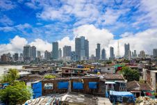
This article explores how some government initiatives in India are utilizing geospatial technologies for better outcomes. The rapid pace of urbanization in India has been an instrument of socioeconomic, political...
This site uses cookies. By continuing to use this website, you agree to our Cookies Policy. Agree