How the National Land Survey of Finland is exploring AI technology
The ATMU project explained
The National Land Survey of Finland (NLS) is a good example of how artificial intelligence (AI) is entering national mapping agencies. Approximately two years ago, NLS set up the Advanced Technology for National Topographic Map Updating (ATMU) project supported by funding from the Finnish Ministry of Finance. This project was focused on developing deep learning solutions for object detection and change recognition, for buildings, roads and hydrographic features (watercourses). By the end of the project, building detection achieved an accuracy of 97.9%, and 96% of building and road changes were correctly identified. The evaluations have been conducted by the NLS experts at the object level.
In November 2020, Finland launched the Artificial Intelligence 4.0 Programme, based on EU objectives and Finland’s strategy to promote the development and introduction of AI and other digital technologies in governments and companies. NLS was identified as one national government agency that could benefit from technological innovation and efficiency improvements. In the map production unit alone, up to a hundred employees work on the stereo models of aerial images for manually updating the topographic map each year. Besides that, many staff members are approaching retirement age. There is therefore an urgent need for new, high-efficiency technology (e.g. AI) to fill the gap. Furthermore, NLS started a new aerial imagery programme (covering one-third of the country annually) and new national Lidar programme (covering one-sixth of the country) in 2020. This resulted in a huge amount of datasets needing to be processed for national topographic map updating.
Deep learning technology has been proven to be highly accurate and effective in object detection, and is regarded as one of the best solutions for reducing the labour-intensive tasks in topographic map updating. Therefore, the ATMU project was launched as the first AI project in the NLS map production department. Its goals were to develop deep learning solutions for object detection and change recognition, to reduce the amount of manual and routine work in GIS production, to improve the accuracy and up-to-datedness of geospatial data, to support the innovation of map production, and to provide high-quality training datasets for society.

Deep learning challenges and solutions
The deep learning technologies in the ATMU project consisted of three main components (Figure 1): input data (training data), neural networks, and output data. In addition, the computational environment is also an important support for deep learning technology.
i) Training data
Deep learning technology is a data-driven technology. Besides the selection of the proper neural network, the quality, quantity and diversity of training data must be considered in order to make very accurate predictions. The training data presented the main challenge at the beginning of the ATMU project.
For example, although orthophotos and building footprints were available in the NLS topographic database, they were not suitable to be used as training data for building detection. The building footprints in the NLS topographic database were collected from the base of a building, whereas the deep learning model detected the roof of a building from images (true orthophotos). This made it impossible to match the building footprints to the true orthophotos. The orthophotos generated from aerial images and digital elevation models (DEMs) in the NLS database created the effect of building tilting. When orthophotos from different years were compared, building roof projections on the orthophotos often varied due to the different camera angles on different aerial vehicles. Unlike orthophotos, true orthophotos eliminate the effect of building tilting since they capture a vertical view towards the surface of the Earth. As a result, pixels on a true orthophoto have a uniform scale, making them measurable. Therefore, the ATMU project decided to use true orthophotos (30cm spatial resolution) instead of orthophotos. The true orthophotos along with building vectors, DEMs and digital surface models (DSMs) were utilized as the training data for building detection. True orthophotos and DSMs were generated by SURE for ArcGIS (Esri product, formerly nFrames). Highly detailed building vectors needed to be collected manually from true orthophotos.
An initial UNet model was trained from scratch with all this training data (Figure 2). When the model could produce a good prediction, the predictions with manual correction were exploited as training data to continue training the model. Thus, the task of manual training data collection was greatly reduced. This strategy ensured the quality, quantity and diversity of training data for high-quality predictions.
The existing resources in the topographic database were not accurate enough to be used as training data for watercourse detection. For watercourses, centrelines of all watercourses (<5m wide) from an area of 36km2 were therefore collected manually. 0.5m Lidar-DEM and watercourse labels with 1.5m buffer were rasterized and trained in the UNet model.

For road detection, orthophotos or true orthophotos (30cm spatial resolution) and road central lines with the width information were utilized as training data. For change recognition of buildings and roads, the training data included true orthophotos from different years, e.g. from 2015 and 2020 respectively, and the manually marked change areas.
ii) Neural networks
During the ATMU project, different neural networks – such as UNet, MaskR-CNN, DenseUNet, RoadVecNet, DSAMNet, MDESNet, Changer, NestNet and NestNet2 – were tested for object detection and change recognition. Different deep learning technologies were also studied, including transfer learning, multi-task learning and transformer/attention mechanism. The neural networks performed as follows during the ATMU project:
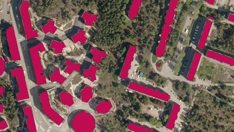
- Building detection: UNet seemed to perform better with the NLS datasets than the other tested neural networks (Figure 3). With transfer learning techniques the result was approx. 5% more accurate when compared to the model trained from scratch. UNet in combination with the transformer did not seem to improve the result. The advantages of the use of a transformer might be clearer if a huge amount of training data were utilized.

- Road detection: UNet, DenseUNet and RoadVecNet were tested with orthophotos from differently coloured spaces. RoadVecNet in combination with RGB images performed the best and was applied to the project. Road detection employed multi-task learning techniques, which means that the neural network can have multiple inputs and multiple outputs. The multiple input data included images from differently coloured spaces together with labels, while the outputs consisted of two parts: road surface segmentation and road edges.
- Watercourse detection: The UNet model was trained with 0.5m Lidar-DEM, and vectors and parameters of the network were optimized.
- Building and road change recognition: NestNet2 performed the best in predicting the changes in buildings and roads from true orthophotos captured in different years (Figure 4).
iii) Computational environment
The training process requires huge computational power. In the ATMU project, deep learning models were trained in Puhti at CSC, Finland’s IT Center for Science. Supported by CSC’s capacity of CPUs and GPUs, Puhti has supercomputers for small and medium jobs. It has a total of 682 CPU nodes. Each node is equipped with two Intel Xeon processors with 20 cores each, i.e. 40 cores in total. The Puhti AI partition has 80 GPU nodes with 4 GPUs per node, totalling 320 NVIDIA Tesla V100 GPUs. CSC’s supercomputers have three main disk areas: home, projappl and scratch. The ‘home’ directory has a storage capacity of 10GiB, while ‘projappl’ has 50GiB and scratch has 1TiB.
Outcomes
By the end of the two years, the ATMU project had produced more than 100,000km2 of true orthophotos, and the UNet model for building detection had been trained with datasets covering an area of more than 60,000km2. According to the NLS expert evaluation, it has reached an accuracy level of up to 97.9% when compared to different reference data. It is now available for the practical use of map production. The option of integrating the ATMU building model with the new topographic database system is currently under discussion.
The AI model (RoadVecNet) for road detection likewise achieved a great result and further application is under consideration. Meanwhile, the preliminary results for watercourse detection using UNet provide a good basis for further research. In addition, expert evaluation of building and road change recognition had been implemented. The results showed that approximately 96% of changes from roads and buildings have been found from true orthophotos using the NestNet2 model. The change detection results can be used as pointers for the operators so that they do not need to check the changed areas across the entire image. This will significantly reduce the amount of manual work. Further application of the change detection method might need to be discussed in the coming year.
The ATMU project has been selected for inclusion in the EuroGeographics annual report representing Finland. In addition, the project has made high-quality training data for building detection publicly available, so it can be used to further boost AI development in the geospatial field.
Further reading
- Finland, 2020. AI strategy: the Artificial Intelligence 4.0 Programme. https://tem.fi/en/-/artificial-intelligence-4.0-programme-to-speed-up-digitalisation-of-business Accessed on 9 February 2023
- Finland, 2021. Artificial Intelligence 4.0 First interim report: from launch to implementation stage. Publications of the Ministry of Economic Affairs and Employment Companies. 12.2021 https://julkaisut.valtioneuvosto.fi/bitstream/handle/10024/163663/TEM_2021_53.pdf Accessed on 9 February 2023
- CSC, 2023. www.csc.fi/ Accessed on 10 February 2023
- Puhti-CSC, 2023. https://docs.csc.fi/computing/systems-puhti/ Accessed on 10 February 2023


Value staying current with geomatics?
Stay on the map with our expertly curated newsletters.
We provide educational insights, industry updates, and inspiring stories to help you learn, grow, and reach your full potential in your field. Don't miss out - subscribe today and ensure you're always informed, educated, and inspired.
Choose your newsletter(s)


