GPS IIR-15 in Orbit
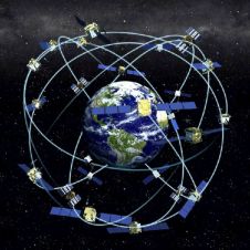
A ‘replenishment’ Block-IIR Global Positioning System (GPS) satellite for the U.S. Air Force has been put into orbit. The Delta II rocket carrying the GPS IIR-15 (M) spacecraft lifted off...
A ‘replenishment’ Block-IIR Global Positioning System (GPS) satellite for the U.S. Air Force has been put into orbit. The Delta II rocket carrying the GPS IIR-15 (M) spacecraft lifted off...
Leica GPS900, a mid-range RTK GPS system that delivers outstanding productivity for a wide variety of tasks, has been introduced by Leica Geosystems (Switzerland). The new Leica GPS900 consists of...
Fastrax Ltd. (Finland) announced the iTrax300, the latest addition to the company's range of OEM GPS receivers. The iTrax300 is based on the SiRFstarIII GSC3 and GSC3-LP chipsets. iTrax300 receivers...
Thales (CA, USA) has introduced Z-Max.Net, a network-capable GPS receiver system for boundary, topographic and construction surveys. Z-Max.Net offers surveyors expanded communications capabilities, simplicity of operation, RTK performance and flexibility...
The first mapping software for handheld GPS navigation devices containing a detailed map of the entire Republic of Mexico has been released by Magallan (CA, USA). MapSend Topo Mexico provides...
GeoSpatial Experts (CO, USA) has unveiled a new GPS photo mapping product bundle that includes a Pentax digital camera, Garmin handheld GPS receiver and the GeoSpatial Experts GPS-Photo Link software....
The collection of Ground Control Points (GCP) for block adjustment is a costly and time-consuming operation. Onboard GPS enables a reduction in the number of GCPs without loss of accuracy....
The area of agricultural fields within the European Union (EU) are checked against claims to ensure that farmers receive the right amount of subsidies. This measure, stemming from EU Common...
Receiver position is calculated from the position of satellites and the distances to them. Distance is calculated from the time a radio signal travels between satellite and receiver. But how...
Ricoh Corporation (CA, USA) has launched the Pro G3, a high-resolution digital camera that embeds captured images with GPS coordinate information received from either its on-board GPS unit or from...
This site uses cookies. By continuing to use this website, you agree to our Cookies Policy. Agree