Oman Launches New Geodetic Datum
Today GNSS is widely used in Oman. High and homogeneous quality of GNSS positioning requires a geocentric datum attached to the International Terrestrial Reference Frame of which the parameters are...
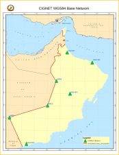
Today GNSS is widely used in Oman. High and homogeneous quality of GNSS positioning requires a geocentric datum attached to the International Terrestrial Reference Frame of which the parameters are...

The A3 Edge digital mapping system is a sweeping camera system able to produce high-resolution and accurate imagery from high flight altitudes and hence to conduct surveys quickly and efficiently....
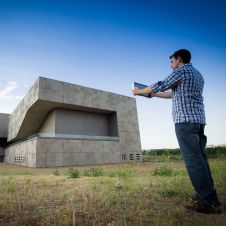
3D documentation work is an important part of an architect´s job. Monuments, old buildings, indoors scenarios, stairs, ornaments, vaults and suchlike have to be captured faithfully on a daily basis....

Tom Bramald and Karen Allenby explore where Newcastle University’s geomatics graduates are finding employment and discuss what makes them employable. Although attracting school leavers to study geomatics at Newcastle University...

Increasingly women are entering the geospatial sector, with many (though not all) holding higher degrees. As the industry becomes more diverse with new opportunities, Ruth Badley talks to three women...
Gexcel, Italy, has attended the joint SPAR Europe and ELMF event to introduce new 3D software tools and solutions focusing on the most recent release of the globally renowned JRC...
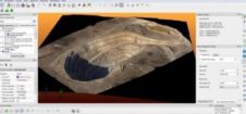
Gexcel, Italy, is attending this year’s Intergeo to introduce new 3D software tools and solutions focusing on the most recent release of the JRC 3D Reconstructor software for UAV platforms....
Teledyne DALSA, a Teledyne Technologies company and a global leader in digital image sensing technology, has introduced the new Remote RadEye HR X-ray camera. It is positioned as a flexible...
The AGISEE SDI workshop is organised by the Association for Geospatial Information in South-East Europe as part of the 4th Croatian NSDI and INSPIRE Day and 8th Cartography and Geoinformation...
This site uses cookies. By continuing to use this website, you agree to our Cookies Policy. Agree