A Journey into the New Reality
In which direction is the geospatial industry heading? Which core activities will companies focus on? How will the rapidly progressing technological advances shape the future? The recent edition of HxGN...

In which direction is the geospatial industry heading? Which core activities will companies focus on? How will the rapidly progressing technological advances shape the future? The recent edition of HxGN...
Leica Geosystems, part of Hexagon, has launched the Leica DMC-4, a highly efficient airborne imaging sensor providing unsurpassed image quality for various applications and complex mapping environments. With the new...

Jürgen Dold, executive vice president at Hexagon, will be delivering the opening keynote at this year’s edition of Intergeo, which will be held from 18 to 20 October in the...

Hexagon has announced that Paolo Guglielmini will succeed Ola Rollén as president and CEO of Hexagon AB, effective from 31 December 2022. Hexagon is a global leader in digital reality...
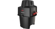
Leica Geosystems, part of Hexagon, has announced the introduction of Leica Chiroptera-5, the new high-performance airborne bathymetric Lidar sensor for coastal and inland water surveys. This latest mapping technology increases...

In this interview, Thomas Harring, president of Hexagon’s Geosystems division and CEO of Leica Geosystems, shares his thoughts on the present and future of the geospatial industry, including his views...

Smart digital realities that replicate real-life geoinformation provide valuable insights and support the analysis and interpretation of infinite data inputs from the real or digital world. They can be used...

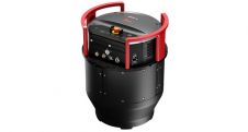
Leica Geosystems, part of Hexagon, has introduced the Leica AP20 AutoPole, an innovative solution for automated total stations that boosts productivity to the next level through tilt compensation, automatic pole...

The German Federal Agency for Cartography and Geodesy (BKG) is creating a digital twin of the whole of Germany that can be used to simulate various future scenarios in order...
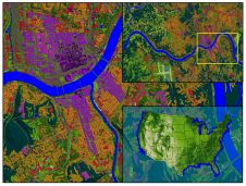
Land Info Worldwide Mapping recently completed up-to-date 10m-resolution thematic raster GIS data covering all 50 US states. Optimized for low-band (broad-area coverage) 5G wireless planning, the dataset supports additional applications including...
This site uses cookies. By continuing to use this website, you agree to our Cookies Policy. Agree