UAS Mapping – Where Is It Heading?
The use of a UAS to acquire geodata for mapping purposes has evolved beyond infancy and is now rapidly maturing. How will it evolve in the foreseeable future? The use...
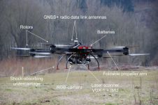
The use of a UAS to acquire geodata for mapping purposes has evolved beyond infancy and is now rapidly maturing. How will it evolve in the foreseeable future? The use...
SBG Systems’ popular INS/GNSS PPK software called Qinertia now covers all surveyors’ projects by offering a licence dedicated to GNSS post-processing, according to the France-based company. Open to the world,...

CHC Navigation provides geospatial professionals with a high-performance, vehicle-independent mobile mapping solution for capturing mass data in constantly evolving global environments. Projects are completed faster and more accurately to increase...

Leica Geosystems, a Hexagon company, has announced a new 3D laser scanning bundle for the Leica BLK360 and greater integration with Autodesk ecosystem. The new bundle consists of the Leica...
Enterprise operations adopting geospatial technology require high accuracy in their digital twins to make them a viable alternative to the real world for measurement and inspection. The challenge is to...

A series of strong earthquakes recently hit populated areas in the south of the Caribbean island of Puerto Rico, causing major damage to properties and infrastructure. Geoxphere and WaldoAir were...
If BIM is applied to the industry effectively, it could allow the built environment sector to accomplish the same productivity gains as the aerospace, automotive and manufacturing industries. According to...
OxTS, experts in inertial navigation has introduced a series of updates to the xNAV and xOEM range of products. The result is greater practicality and improved functionality from OxTS’ survey-friendly...
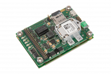
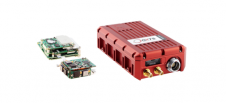
Septentrio, a leading global supplier of high-accuracy positioning technology for demanding applications has announced today a new addition to their GNSS/INS portfolio. AsteRx-i S UAS combines GNSS technology with industrial-grade...
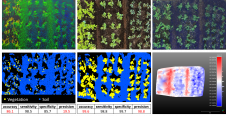
Precision agriculture has considerably benefited from the use of unmanned aerial vehicles, often combined with active ranging sensors like Lidar to gather information from underneath the crops, but existing systems...
This site uses cookies. By continuing to use this website, you agree to our Cookies Policy. Agree