New German Cadastre Standard
On 1st July 2007, the Surveying and Cadastre Authority of the German Federal State of Lower Saxony (LGN) announced the general technical acceptance of the Data Acquisition and Qualification component...
On 1st July 2007, the Surveying and Cadastre Authority of the German Federal State of Lower Saxony (LGN) announced the general technical acceptance of the Data Acquisition and Qualification component...
Spatial delimitation of ownership rights remains absent from the land-registration procedure in Iceland, resulting in confusion. Increasing value of land has, among other issues, induced the need to move from...
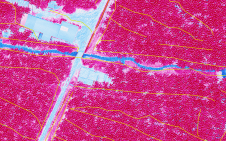
Photogrammetry and Lidar were used together in Ecuador to detect irrigation and drainage canals for a project aiming to improve irrigation methods and create the related land registry. The integration...
Prior to the year 2000, less than half of the parcels in Jamaica were formally registered, and even the simplest of land transactions took weeks to complete. In 2001, those...
Bennett and co-authors from the University of Melbourne, Australia, have described six design elements relating to the role and nature of future cadastres, presented at the FIG 2010 congress in...
GAF AG (Germany) has been awarded a contract to set-up a new computerised and countrywide mining cadastre system for Nigeria. After the successful completion of contract negotiations GAF has started...
In the city of Manica, a planning exercise based on the principles of participatory community planning is currently taking place in the Josina Machel neighbourhood. The city is one of...

In 2017, Suriname’s Ministry of Land Management decided to digitize and automate the process of citizen requests for land and the management of land, which had mainly been paper-based for...

Armenia is moving towards a more transparent, secure, unified and citizen-oriented cadastral system. To achieve this, digitizing cadastral archives is essential. Digital availability of cadastral information will enable better management...

The Open Geospatial Consortium (OGC) membership seeks to form a new Land Administration Domain Model (LADM) Standards Working Group (SWG). Public comment is sought on its draft Charter. Comments are...
This site uses cookies. By continuing to use this website, you agree to our Cookies Policy. Agree