Chameleon v2.0
DM Solutions Group (Canada) has made available Chameleon version 2.0, an Open Source software for creating customisable Web mapping applications. This latest version provides the flexibility to utilise both remote...
DM Solutions Group (Canada) has made available Chameleon version 2.0, an Open Source software for creating customisable Web mapping applications. This latest version provides the flexibility to utilise both remote...

Unicore Communications, Inc. is a high-tech company dedicated in high performance satellite positioning, multi-sensor fusion algorithm development, and highly integrated GNSS IC design. With the advantage of talent, management, technology...

Looking for a recipe for business success in surveying? Don't underestimate the importance of innovative surveying services, says Moritz Lauwiner. The latest measurement sensors and software, decades of collective experience...

The fourth edition of Geo Connect Asia (GCA), celebrated as the region's premier trade event and conference for the geospatial, positioning and remote sensing industries, truly delivered during its two-day...

Despite some uncertainty, there is renewed interest in drones, and remote sensing technologies are being embraced by smaller survey companies. Read these and other findings from our annual industry survey!...

NavVis recently unveiled a substantial enhancement in global 3D spatial technology access and performance. By launching new cloud regions in the Americas and Asia-Pacific (APAC), the company aims to elevate...
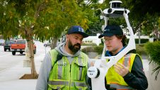
Join Noah Eckhous from NavVis and Mike Walle from Denn Engineers in downtown Culver City to explore how SLAM-based data capture technology transforms topographic survey workflows. In this video, we...
Esri is to take part in several side events at the United Nations Conference on Sustainable Development (Rio+20). The conference will be held from 20 to 22 June 2012 in...
LizardTech, USA, celebrates its 20th anniversary this year. As part of the celebrations, and to reflect on how it all started with the introduction of MrSID two decades ago, the...
VisionMap’s A3 ground processing system version 2.0 is now released. The ground processing system, together with A3 camera improvements now feature better radiometry, higher resolution DSM processing, as well as...
This site uses cookies. By continuing to use this website, you agree to our Cookies Policy. Agree