Effectively Using Point Cloud Fly-throughs for Marketing
On social media, the average post receives only a few seconds of attention. At trade shows, first impressions determine whether attendees visit a booth. The first moments also set the...

On social media, the average post receives only a few seconds of attention. At trade shows, first impressions determine whether attendees visit a booth. The first moments also set the...
Tallysman Wireless has announced the addition of its first full-band GNSS antenna to its industry-leading line of Helical antennas. The full-band GNSS HC990E embedded helical antenna is designed for precise...

Simultaneous localization and mapping (SLAM) is not a specific software application, or even one single algorithm. SLAM is a broad term for a technological process, developed in the 1980s, that enabled robots to navigate autonomously through new environments without a map. Simultaneous localization and mapping (SLAM) is not a specific software application, or even one single algorithm. SLAM is a broad term for a technological process, developed in the 1980s, that...
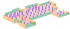
A new algorithm has been developed that automatically identifies architectural elements and creates 3D models of building interiors. Over the last decade, the demand for digital twins has increased in...

An inertial navigation system (INS) is a critical part of a surveyor’s armoury. The measurements provided by the INS, including heading, pitch/roll, timing and absolute position, ensure that surveyors can confidently measure their environment, safe in the knowledge that every area and angle is covered precisely. An inertial navigation system (INS) is a critical part of a surveyor’s armoury. The measurements provided by the INS, including heading, pitch/roll, timing and absolute position, ensure that surveyors can...

Intelligent Inertial Navigation Systems for Survey and Mapping Applications Whether the mode of collection is land-based, aerial, or marine, our robust GNSS-aided inertial navigation systems provide accurate georeferencing data around...
A new INS from Oxford Technical Solutions aims to break new ground in bringing high-quality navigation data to the Lidar surveying industry. Launched on 22 March 2021, the xNAV650 promises...

Crew-B – a trio of young entrepreneurs – recently discovered the best tool to scan multiple sites in a single day. Their client, a European leader in the fitness market,...

Leica Geosystems, part of Hexagon, has announced a reality capture solution combining Boston Dynamics’ agile mobile robot Spot with the Leica RTC360 3D laser scanner. By programming the devices to...

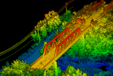
There is a general acknowledgement in the scanning and mapping industry that, compared to terrestrial laser scanners (TLS), mobile mapping systems significantly increase scanning speed and point cloud coverage. This is especially true for building interiors and equipment. This results in reduced time on site, which in turn lowers the cost of scanning for the service provider. There is a general acknowledgement in the scanning and mapping industry that, compared to terrestrial laser scanners (TLS), mobile mapping systems significantly increase scanning speed and point cloud coverage. This...
This site uses cookies. By continuing to use this website, you agree to our Cookies Policy. Agree