UNAM selects RIEGL sensor as its first aerial Lidar system
The University of Nacional Autónoma de México (UNAM) has recently procured a RIEGL VQ-1560 II-S airborne system through its Institute of Geography. It has been added to the R&D project...
The University of Nacional Autónoma de México (UNAM) has recently procured a RIEGL VQ-1560 II-S airborne system through its Institute of Geography. It has been added to the R&D project...
The new state-of-the-art Phase One P5 128MP camera has been seamlessly integrated into Quantum Systems’ flagship Trinity Pro mapping drone and the leading surveying workflow, Trimble Business Center. The resulting purpose-built,...
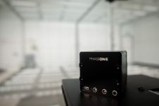
Phase One has inaugurated a calibration lab and geospatial centre of excellence in Denver, Colorado, USA. The new facility has been specifically designed to accelerate precise calibration of cameras across...
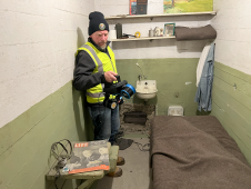
The rugged 22.5-acre site of the notorious US island prison Alcatraz has been digitally captured in a world-leading project involving multiple mapping technologies. With the team camped in the jail’s infamous cells for three weeks during the cold San Francisco winter, this historically, biologically and architecturally important location was recorded in unprecedented 3D detail. We discussed the project with project head Pete Kelsey and team member Dr Jeremy Sofonia. The rugged 22.5-acre site of the notorious US island prison Alcatraz has been digitally captured in a world-leading project involving multiple mapping technologies. With the team camped in the jail’s infamous cells...
3D TARGET was founded as a trading company and official distributor of non-destructive measuring instruments. In 2016, we created an internal R&D division dedicated to system integration and designed a...
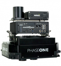
Phase One has launched the 280MP Aerial Solution, a large-format aerial photogrammetric system, with an image coverage width of more than 20,000 pixels. The new aerial mapping solution is designed...

3D visualization is at the heart of many geospatial data applications. Progress in 3D visualization has drastically reduced barriers to entry for new products based on large datasets, thanks to...

Phase One , a provider of medium-format metric cameras and imaging solutions for aerial applications, has signed an agreement with Aerialtronics DV, a developer of end-to-end aerial data capture solutions....

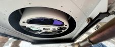
Lead’Air has recently developed a new MIDAS 300P with a Phase One IXU-R 1000 - 100mp nadir camera with a 50mm lens and four Phase One IXU 150 - 50mp...

The Open Maps For Europe 2 (OME2) project has revealed plans to boost the utilization of European cadastral data. This includes efforts to enhance its discoverability and accessibility. As part...
This site uses cookies. By continuing to use this website, you agree to our Cookies Policy. Agree