Phase One, Quantum Systems and Trimble launch survey-grade UAV solution
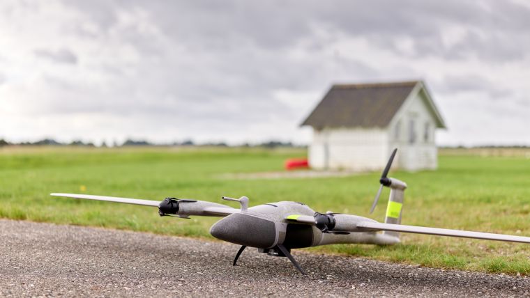
The new state-of-the-art Phase One P5 128MP camera has been seamlessly integrated into Quantum Systems’ flagship Trinity Pro mapping drone and the leading surveying workflow, Trimble Business Center. The resulting purpose-built, survey-grade, end-to-end unmanned aerial vehicle (UAV or ‘drone’) solution was unveiled at Trimble Dimensions in Las Vegas, USA, in early November.
The surveying and construction industry confronts a wide range of challenges, including the critical aspects of time constraints, resource limitations, project requirements, and the potential for costly fines due to project delays. Traditional surveying methods have proven to be time-consuming to reach the statistical confidence needed in data quality, which further intensifies the challenge of monitoring construction progress in a timely manner. Delayed delivery of critical projects not only results in substantial financial penalties but also hampers overall industry progress.
Accurate surveys play a critical role in construction projects and architectural design, whether during the construction phase or in the post-completion monitoring stage. However, current UAV-based surveying solutions have often fallen short in capturing survey-grade quality data, leaving a critical gap in meeting industry demands.
Addressing shortcomings of conventional cameras
In the realm of specialized camera systems, the Phase One P5 has been meticulously crafted to address the shortcomings of conventional cameras for UAVs in terms of speed, weight and data quality. Purpose-built for aerial surveying via drone and with an impressive 128 megapixels, the camera stands as the world’s pioneering solution, consistently delivering the highest resolution and accuracy, along with industry-standard metrical calibration.
The Phase One P5 camera is integrated into Quantum Systems’ Trinity Pro UAV, facilitating high-productivity missions with a ground speed of up to 22m/s while maintaining safe operational altitudes ranging from 60 to 120m AGL. This enables the rapid surveying of large-scale areas with just a single flight. 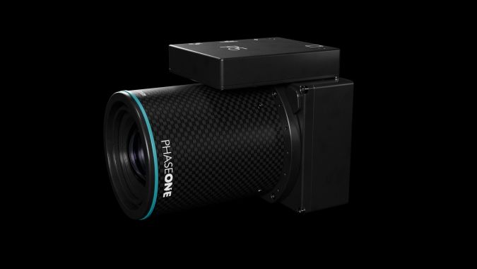
Benefits for construction engineering
This integration presents an extensive range of benefits for construction engineering customers due to its guaranteed precision and survey-grade data accuracy. This exceptional level of detail and accuracy is paramount for construction projects, fostering confident decision-making while simultaneously minimizing post-processing efforts. Consequently, these features establish the joint solution as an indispensable tool for construction engineering professionals, streamlining large-scale data collection, and delivering unparalleled efficiency.
Moreover, Phase One P5 enhances productivity and addresses the industry’s surveyor shortage by being deployed in conjunction with Quantum Systems Trinity Pro. With a proven track record of over 75,000 flight hours, the Trinity Pro ensures reliability and reduces maintenance requirements, allowing surveyors to focus on their core tasks. 
Improve productivity and profitability
Designed as an end-to-end surveying instrument, the Trinity Pro and Phase One P5 solution seamlessly integrates into the Trimble Business Center (TBC) workflow, setting a new standard for engineering surveying. The modern surveyor will benefit from state-of-the-art technology to improve productivity and increase profitability.
“We are proud to introduce a pioneering solution that not only addresses the profound challenges faced by the surveying and construction industry, but also sets new benchmarks for efficiency and precision,” said Robert Leake, head of commercial sales at Quantum Systems. “Our collaboration with Phase One and Trimble has yielded a game-changing survey-grade UAV solution. Achieving this level of quality, detail and accuracy within a fixed-wing platform is a first in the industry. We’re opening new horizons for engineering surveying professionals, and we’re excited to be at the forefront of this revolutionary leap forward.”

Opening up new horizons
“Each Phase One P5 camera undergoes factory metric calibration and is supplied with a calibration certificate. When integrated with the Trinity Pro system, the Phase One P5 swiftly and accurately covers large survey areas, resulting in significant time and cost savings compared to traditional mapping and surveying methods,” states Michael Messerschmidt, director product management unmanned at Phase One.
The utilization of an electronic global shutter, combined with precisely calibrated lenses and sensor, minimizes the need for extensive post-processing and software corrections typically required to address pixel distortion, thereby ensuring the preservation of high-quality data.
With the launch of the Phase One P5 camera and the complete survey-grade UAV solution, Quantum Systems, Phase One and Trimble are opening up new horizons for professionals in the field of aerial engineering surveying.
For additional information on the Phase One P5 camera, go to https://geospatial.phaseone.com/drone-payload/p5/

Value staying current with geomatics?
Stay on the map with our expertly curated newsletters.
We provide educational insights, industry updates, and inspiring stories to help you learn, grow, and reach your full potential in your field. Don't miss out - subscribe today and ensure you're always informed, educated, and inspired.
Choose your newsletter(s)


