Free World Cup Stadium Viewer
To celebrate the opening of the 2010 World Cup in South Africa, AAM and partner company, AOC Geomatics, have released two products on their websites: movies/fly throughs of the stadiums...

To celebrate the opening of the 2010 World Cup in South Africa, AAM and partner company, AOC Geomatics, have released two products on their websites: movies/fly throughs of the stadiums...
Everyone who truly matters in the geomatics and surveying-related business will be travelling to Germany ¨C or more precisely to the Bavarian city of Nuremberg ¨C in the last week...

Bluesky is rolling out nationwide coverage of its Solar Suitability Map. By mapping the potential for power generation using solar panels on roofs, the Solar Map is designed to identify...
From the Marine Equipment Trade Show (METS) 2010 exhibition, Hemisphere GPS, Canada, expanded its multi-million dollar OEM agreement with ComNav Marine of Vancouver, Canada. Hemisphere GPS will manufacture the world's...
Hemisphere GPS announced the release of two very compact GPS compass products; the V102 all-in-one and the H102 OEM module. These products are ideal where heading and positioning are needed...
The 8th European Satellite Navigation Competition (ESNC) is to be launched during a kick-off conference on 10th and 11th May 2011. The event, hosted by the Institute of Engineering and...
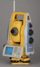
Topcon's Imaging Station, the IS-3, increases the longest scanning range to 6,500 feet (2,100m). Its patented prism tracking scanning interface technology X-TRAC 8 has, according to senior vice president of...
NovAtel (Canada) has introduced its enhanced ALIGN solution, as part of the 6.100 firmware release. The solution is available in two models: ALIGN Heading and ALIGN Relative Positioning. The two...
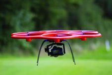
An agreement with Germany-based hexacopter manufacturer Aibotix improves the position of KOREC, headquartered in the UK, in the UAV sector. The company will be an Aibotix ‘Premier Partner’ and the...
My Endpoint column in the February 2011 issue touched upon general characteristics of Unmanned Aerial Vehicles (UAV). Here, I focus on low-weight, low-altitude and the built environment. Low-weight UAVs are...
This site uses cookies. By continuing to use this website, you agree to our Cookies Policy. Agree