Grow Your Knowledge: GNSS & Positioning
We regularly keep you informed about the latest developments in the field of mapping and surveying through our articles in 'GIM International', and we have recently expanded this with a...
We regularly keep you informed about the latest developments in the field of mapping and surveying through our articles in 'GIM International', and we have recently expanded this with a...
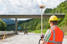
The world of surveying and positioning is experiencing an amazing transformation that began just recently, and goes hand in hand with the superior push in technology democratisation due to the...
Topcon Europe Positioning co-operates with a new partner in the France. With Laser Equipement, Topcon aims to provide its customers with a strong basis for further expansion of its sales...
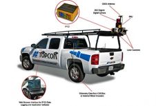
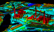
Topcon Positioning Systems recently unveiled the IP-S2, a vehicle-mounted, mobile 3D precision mapping and survey system. The IP-S2 combines dual-frequency GNSS signal tracking and positioning and inertial measurement to integrate...
GPS is good for perhaps 70% of surveying needs. Inertial Navigation is the forgotten friend of GPS. Traditionally complex and expensive, Inertial Navigation has become competitive, easy-to-use and cost-effective. Need...
NovAtel Inc. (Canada) has launched its new Real Time Kinematic (RTK) precise positioning solution – AdVance RTK. NovAtel’s GNSS OEMV-2 and OEMV-3 receivers will now be available with the new...
"Welcome to the future!" This was how Topcon greeted Intergeo visitors to their stand. It was impossible to overlook. So what is so special about that future? And how is...
"Welcome to the future!" This was how Topcon greeted Intergeo visitors to their stand. It was impossible to overlook. So what is so special about that future? And how is...
Woolpert has forged a strategic alliance with Allvision with the goal of enhancing geospatial artificial intelligence capabilities and applications. This partnership seamlessly integrates Pittsburgh-based geospatial analytics and asset management company...
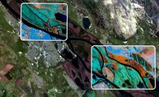
European Space Imaging (EUSI) has recently have announced a strategic partnership giving users direct access to the world's most detailed hyperspectral imagery from Pixxel. Combined with EUSI’s capability to build...
This site uses cookies. By continuing to use this website, you agree to our Cookies Policy. Agree