Woven Into Fabric of Society
3D Laser Mapping, a company specialised in laser-mapping systems, operates from headquarters near Nottingham in the United Kingdom. In addition to airborne Lidar, 3D Laser Mapping has pioneered terrestrial Lidar...
3D Laser Mapping, a company specialised in laser-mapping systems, operates from headquarters near Nottingham in the United Kingdom. In addition to airborne Lidar, 3D Laser Mapping has pioneered terrestrial Lidar...
Terrestrial 3D laser scanning will become the future standard tool for high-resolution 3D documentation of archaeological excavations, but its capabilities are still underestimated by professional archaeologists and providers of scanners...
MAPPS (VA, USA) has announced that George Southard, Vice President Americas Digital Imaging of Leica Geosystems, Englewood, CO has been elected chairman of the newly formed MAPPS Associate Members Committee....
The annual ASPRS 2008 Conference took place this year in the city of Oregon (USA), with the theme ‘Bridging the Horizons: New Frontiers in Geospatial Collaboration’.<P> Over 1,250 attendees made...
With over 580 registered delegates from 32 countries, forty international exhibitors and nearly a hundred abstracts submitted, the eighth annual International Lidar Mapping Forum(ILMF) reflected the growing importance of Lidar...
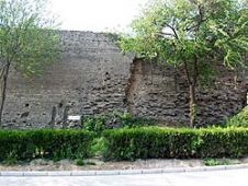
The Great Wall of China is one of the largest manmade wonders of the world, comprising many different and irregular structures. We employed airborne Lidar to produce highly accurate digital...

North American cities have been documented at speed using StreetMapper, using vehicle mounted laser scanners to capture highly detailed and accurate measurements at speed. The technique was developed and supplied...
Diamond Airborne Sensing (Austria) has obtained a certification for the DA42 MPP for its laser scanning configuration. The certified belly pod design is able to carry different sensor equipment up...
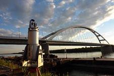
State-of-the-art geodetic and remote sensing techniques can prove their potential through particular engineering applications. Here we discuss load test measurements of bridges over the Danube. Prior to the particular bridge...
Intergeo, the world’s largest congress and trade-fair for geodesy, geoinformation and land management, will this year be held in Karlsruhe, Germany, from 22nd to 24th September. About 16,000 visitors are...
This site uses cookies. By continuing to use this website, you agree to our Cookies Policy. Agree