Lidar survey in cloudy conditions in Cameroon
A dynamic field of view feature was used to overcome the inability of Lidar laser beams to penetrate persistent cloud cover in this project in Cameroon. In Lidar surveys, minimizing...
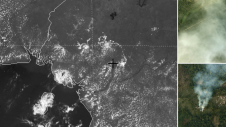
A dynamic field of view feature was used to overcome the inability of Lidar laser beams to penetrate persistent cloud cover in this project in Cameroon. In Lidar surveys, minimizing...

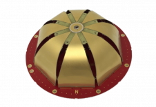
An inertial navigation system (INS) is a critical part of a surveyor’s armoury. The measurements provided by the INS, including heading, pitch/roll, timing and absolute position, ensure that surveyors can confidently measure their environment, safe in the knowledge that every area and angle is covered precisely. An inertial navigation system (INS) is a critical part of a surveyor’s armoury. The measurements provided by the INS, including heading, pitch/roll, timing and absolute position, ensure that surveyors can...

Septentrio has launched a new product line of high-performance GNSS/INS receivers called AsteRx-i3. The AsteRx-i3 product family brings to market an array of next-generation receivers from plug-and-play navigation solutions to...

Aerial mapping company Bluesky International has purchased the very latest high-performance aerial mapping sensor from Hexagon to secure its position as the leading UK provider of 3D mapping data. The...

Carmaker Audi is using a specially developed UAV system to locate vehicles that are ready for dispatch at its Neckarsulm site. The unmanned aerial vehicle (UAV or 'drone') flies over...

Harxon has just launched its TS112 family of smart antennas, designed for demanding applications such as autosteering systems for agricultural machinery that require high positioning-accuracy solutions. The newly released TS112...
Teledyne Optech, the Canada-based advanced Lidar sensors company, has extended its Galaxy line-up to include the CM2000, a new sensor specifically designed for corridor mapping. With a true measuring rate...

The Geospatial Commission has improved access to Ordnance Survey MasterMap data and released core location identifiers under Open Government Licence. All of us interact with address and street information on...
Tallysman Wireless has announced the addition of four new embedded VeroStar products to its line of antennas. According to the Canada-based antenna manufacturer, the compact and light embedded VeroStar models...
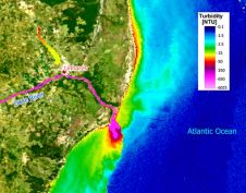
Lactec and EOMAP are partnering up to carry out projects in Brazil to improve mapping and monitoring of aquatic environments using geospatial intelligence. Lactec is Brazil's leading company in innovation...
This site uses cookies. By continuing to use this website, you agree to our Cookies Policy. Agree