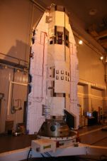
First Galileo Satellite Repositioned
Surrey Satellite Technology (SSTL), UK, has completed the repositioning of the first Galileo test satellite, GIOVE-A, to a higher orbit to make way for the operational satellites of Europe's satellite...
Surrey Satellite Technology (SSTL), UK, has completed the repositioning of the first Galileo test satellite, GIOVE-A, to a higher orbit to make way for the operational satellites of Europe's satellite...
GeoEye-1 stereo satellite imagery is capable of producing Digital Terrain Models (DTM) with better then 0.5m vertical accuracy. AAMHatch tasked the GeoEye-1 satellite to capture stereo data over a 270sqkm...
Following exponential growth in the space sector, Messe Stuttgart (Germany) has created POSITIONALE, an international trade fair and conference for satellite positioning, navigation and telematics technologies. The expo will run...
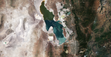
Utah’s Great Salt Lake dropped to its lowest recorded water level last month as a megadrought persists across the US southwest, forcing the fast-growing city to curb its water use....
Satellite imaging provider DMCii has announced that it will provide free DMC constellation satellite imagery for scientists to support global environmental monitoring projects. Scientists are invited to compete for the...
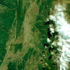
The first public release of a RapidEye image has been unveiled. This demonstration image highlights the capabilities of RapidEye imagery in many market segments, by showing diverse landscapes that include...
GeoEye (VA, USA), has announced the launch of the world\'s highest resolution, commercial Earth-imaging satellite, which is scheduled for 4th September 2008, from Space Launch Complex-2 at Vandenberg Air Force...
The European Space Agency is about to launch a mission to investigate the Earth's gravitational field and to map the reference shape of our planet - the geoid - with...
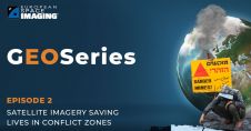
From locating and disarming landmines to combating illegal mining, monitoring armed conflict, mapping internally displaced populations and subsequent camps as well as tracking oil pollution affecting local citizen’s health and...
Space-programme research and development over the past five decades has culminated today in the broad practical application of advanced earth observation (EO) technologies. Satellite technologies are now reaching a level...
This site uses cookies. By continuing to use this website, you agree to our Cookies Policy. Agree