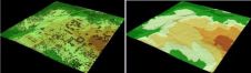
Point Clouds (1)
Whether based on Lidar, photogrammetry, radar, sonar or other remote sensors, systems for geodata acquisition create millions or even billions of 3D points. To be useful, the data needs to...
Whether based on Lidar, photogrammetry, radar, sonar or other remote sensors, systems for geodata acquisition create millions or even billions of 3D points. To be useful, the data needs to...
To be useful, the millions or even billions of 3D points generated by a variety of active and passive sensors need to be stored, organised, combined, georeferenced, measured and analysed,...

The main users of geodemographic segmentation systems have traditionally been commercial direct marketing companies, academics, and large retailers. Latterly they have been accepted by public sector organisations as being very...

GW kick-starts the New Year with a strong focus on laser scanning and particularly point cloud software. Both topics that no doubt we will be returning to again during the...

Optech, Canada, is to attend the Asia Geospatial Forum 2014 being held from 25-27 November 2014 in Jakarta, Indonesia. At the forum, Optech will be showcasing several new technologies, plus...
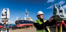
The world of hydrography is being opened up for new applications using a variety of boat-mounted sensors. Measurement of the relative positions of the sensors on board is vital for...
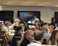
Teledyne Optech has been looking back on a successful 2015 Imaging and Lidar Solutions Conference (ILSC) which concluded on Friday, 12 June. Visitors from across the globe came together in Toronto, Canada,...

Trimble Applanix designs, builds, delivers and supports products and solutions designed specifically for the hydrographic survey industry. Our products and solutions provide robust, reliable and repeatable positioning and motion compensation...
Proposals to privatise the Land Registry take centre stage whilst we also examine the latest inshore hydrographic technology, the Internet of Things, BIM and someone thinks ‘the times they are...
Today’s geodata acquisition technologies combine microprocessors, computer power, solid state drives, complementary metal-oxide-semiconductor (CMOS) sensors, miniaturisation and many more developments. But demand is just as important as supply, and demand is...
This site uses cookies. By continuing to use this website, you agree to our Cookies Policy. Agree