Bad news and good
The financial crisis is hammering the foundation of global society and the effects are increasing in rate and force on a daily basis. Like a bolt from the blue, we...
The financial crisis is hammering the foundation of global society and the effects are increasing in rate and force on a daily basis. Like a bolt from the blue, we...
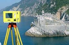
When surveying the coastline, the integration of bathymetric (below sea level) and laser scanning (above sea level) data causes problems due to the different imaging properties. However, by ensuring that...
The geomatics and hydrographics field is flourishing as never before; nevertheless, it is experiencing a shortage of personnel. Companies and governments simply cannot attract sufficient qualified personnel to get all...
The engineering consultancy DHV (Netherlands) has been commissioned, together with the Chinese planning institute Qinghua and the Arup consultancy from the UK, to carry out a prestigious coastal and urban...
Established in 1868 by Govert van Oord, Van Oord is today a conglomerate of Dutch dredging companies, lately best known as constructor of Palm Island, Dubai, the ‘Eighth Wonder of...
Three years ago a mighty submarine earthquake lifted the floor of the Indian ocean, triggering a vast rush of water what surged towards the coasts of India, Indonesia, the Maldives,...
Photo Science (KY, USA) has been awarded a five-year IDC contract by the National Oceanic & Atmospheric Administration (NOAA) to provide aerial photography and photogrammetric mapping services to support of...
Intergraph Corporation has partnered with the Italian government to safeguard the Venice lagoon from the rising tides of the Adriatic Sea, which threaten to erode this distinguished city and erase...
The combination of 3D-laser scanning and side-scan sonar can be very beneficial for mapping complicated waterside areas; the two systems are complementary. High-resolution surveys were performed over a two-year period...
Traditional horizontal and vertical datum have two separate origins: respectively Earth’s centre of mass as origin for horizontal, and mean sea level (the geoid) as origin for vertical. The author...
This site uses cookies. By continuing to use this website, you agree to our Cookies Policy. Agree