New UN organization to highlight the value of geodesy
The brand-new United Nations Global Geodetic Centre of Excellence (UN-GGCE) is now operational at the United Nations campus in Bonn, Germany. Nicholas Brown, head of office of the UN-GGCE, is...

The brand-new United Nations Global Geodetic Centre of Excellence (UN-GGCE) is now operational at the United Nations campus in Bonn, Germany. Nicholas Brown, head of office of the UN-GGCE, is...

Unicore Communications, Inc. is a high-tech company dedicated in high performance satellite positioning, multi-sensor fusion algorithm development, and highly integrated GNSS IC design. With the advantage of talent, management, technology...

Despite some uncertainty, there is renewed interest in drones, and remote sensing technologies are being embraced by smaller survey companies. Read these and other findings from our annual industry survey!...

UNESCO organized an intensive training course for more than 20 cultural heritage professionals from eight regions of Ukraine threatened by increasingly frequent attacks, including the cities of Odesa, Kyiv and...
Trimble has announced a collaboration with the Indian Institute of Technology in Kanpur (IIT Kanpur) to support a new UAV programme offered by the Department of Aerospace Engineering. Trimble's contribution...

Incorporating smart methodologies in cadastral surveying is improving the land acquisition system in Ghana. Traditional cadastral surveying is time-consuming and, if not planned out well, could cost a fortune to...

The coming years look promising for the geomatics sector, but the new generation of professionals must be prepared to face the challenges ahead. In view of the looming labour shortage...
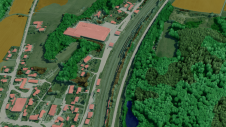
Innovative methodologies based on artificial intelligence (AI) are lowering the barriers and democratizing the use of 3D digital twins in the geospatial industry. Digital twins are revolutionizing the geospatial industry,...

Blue Marble Geographic’s flagship software, Global Mapper Pro, is an all-in-one GIS package for analysing and processing vector, terrain, image and point cloud data. Compatible with over 380 different file...
GeoCue’s 2012 Training Event will be held from 17 to 21 September 2012 in Nashville, USA. The GeoCue 2012 Training Event provides a range of courses on all supported GeoCue,...
This site uses cookies. By continuing to use this website, you agree to our Cookies Policy. Agree