Civil Applications of UAVs
While drones do have military pedigree, their continued development has led to a proliferation of designs suitable for almost any application where real-time data gathering is critical. This now includes...
While drones do have military pedigree, their continued development has led to a proliferation of designs suitable for almost any application where real-time data gathering is critical. This now includes...
The annual ACSM Annual Survey Summit, which took place from 21 to 24 July 2012 in the Grand Hyatt in San Diego, USA, brought together 265 industry professionals from 13...

In response to the growing interest in Unmanned Aerial Vehicles/Unmanned Aerial Systems (UAV/UAS), this category has now been added to the Companies Directory, thus making them easier to find. Any...
Unmanned Aerial Systems (UAS), will be used from 21 to 23 August 2012 to monitor Missouri River bank erosion on the Lower Brule Reservation, S.D., USA. The flights, conducted for...
Abstract submissions are now being accepted for The Institute of Navigation’s (ION) newest conference, PACIFIC PNT to be held 22-25 April 2013 at the Marriott Waikiki Beach Resort & Spa,...
MAVinci Desktop is a professional software that handles all UAV-related tasks from flight planning to UAV control. MAVinci will be showing new features during Intergeo, to be held from 9...
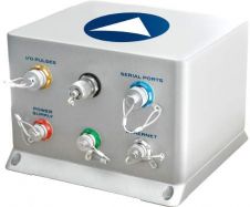
iXBlue, France, has presented ATLANS as a cost-effective georeferencing and orientation system, designed for land and airborne mapping applications. The user obtains a compact, lightweight gyrocompass and motion sensor that...

MAVinci will be offering exciting live UAS flight demonstrations next to the Hanover fair area at Intergeo from 9 to 11 October 2012. Visitors to the UAS demonstration can watch...

Where should I start in this, our thickest issue of the year? We’re in the midst of exciting times, not only in our profession but also within our publishing company,...

Intergeo has once again opened its doors today in Hanover, the capital of the German state of Lower Saxony. This year, around 520 exhibitors from across the globe are highlighting...
This site uses cookies. By continuing to use this website, you agree to our Cookies Policy. Agree