GIM - March/April 2020
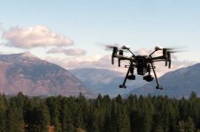
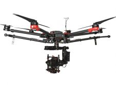
In line with tradition, the March-April issue ofGIM International includes several articles on unmanned aerial vehicles (UAVs or 'drones'). Over the past years, UAVs have become a vital tool for...
In line with tradition, the March-April issue ofGIM International includes several articles on unmanned aerial vehicles (UAVs or 'drones'). Over the past years, UAVs have become a vital tool for...
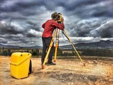
Over the next ten years, the surveyor’s workflow will become quicker, safer and easier because of new technologies such as scanning, mobile mapping and UAS photogrammetry. Virtual layout, aided by...
The advancement of new technology in the geospatial industry is opening up new horizons for surveyors. The profession has rapidly become high-tech, which has brought many benefits and also an...
In June 2018, RSPSoc's 'Photogrammetric Record' publication devoted 11 pages to determining which term they would use for drones. They ultimately decided on ‘unmanned aircraft system’ or ‘UAS’. However, the...
Phase One, a world-leading provider of medium-format metric cameras and imaging solutions for aerial applications, has signed an agreement with AI-Survey, a developer of UAS survey packages, services and tailor-made...

Read this interview with five pioneers in the field for insights into the best ways to introduce drones into your business model. Unmanned aerial vehicles (UAVs or 'drones') are increasingly...
PrecisionHawk has received a US$32 million investment from venture investors including Millennium Technology Value Partners, Third Point Ventures, Eastward Capital Partners, and others. The company will use this financing to...

Scotland’s Edinburgh Napier University has received a gift from Trimble to establish a state-of-the-art Technology Lab for architecture, engineering and construction (AEC). The lab will expand the university’s leadership in...
Terra Drone, Japan, has signed an investment agreement with Unmanned Aerial Services Incorporated (UAS Inc.), an Ontario, Canada-based inspection service provider for indoor industrial confined spaces and underground mine locations....

Intergeo is a leading annual industry showcase where geospatial professionals gain an excellent impression of the latest innovations. On the brink of a new decade, Intergeo 2019 gave us a...
This site uses cookies. By continuing to use this website, you agree to our Cookies Policy. Agree